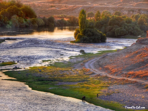
The Tigris is the eastern member of the two great rivers that define Mesopotamia, the other being the Euphrates. In Greek, Mesopotamia means between two rivers. The river flows south from the mountains of southeastern Turkey through Iraq and empties itself into the Persian Gulf. The Ancient Greek form Tigris was borrowed from Old Persian Tigrā, itself from Elamite Tigra, itself from Sumerian Idigna. The original Sumerian Idigna or Idigina was probably from “running water”, which can be interpreted as “the swift river”, contrasted to its neighbor, the Euphrates. Another name for the Tigris used in Middle Persian was Arvand Rud, literally “swift river”. Today, however, Arvand Rud refers to the confluence of the Euphrates and Tigris rivers (known in Arabic as the Shatt al-Arab). In Kurdish and in southeastern Turkey the river is known as Dicle also known as Ava Mezin, “the Great Water”. Rising in the Taurus mountains of southern Turkey, the Tigris flows southeast through Iraq, where in the southern part of that country it merges with the Euphrates to become the Shatt al Arab, which then flows to the Persian Gulf. The river has numerous small tributaries running from its eastern bank, and is 1,180 miles (1,899 km) in length.


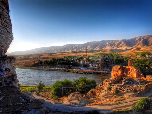
Hasankeyf is rich in history throughout the ages and aside from the sites below, at the level of the river, thousands of caves exist in the cliffs that surround the city. Many of the caves are multi-storied and have their own water supply. Churches and mosques were also carved into the cliffs and numerous ancient cemeteries exist throughout the area. Hasankeyf is an ancient settlement that has had many names from a variety of cultures during its history. The variety of these names is compounded by the many ways that non-Latin alphabets such as Syriac and Arabic can be transliterated. Underlying these many names is much continuity between cultures in the basic identification of the site. I plan to write more about Hasankeyf in the next post but I had these beautiful and peaceful photographs at sunset and thought I would devote this post to the Tigris River itself.


The Taurus Mountains, called as Toros in Turkish, are a mountain range in the Mediterranean region of Turkey, running approximately 560 kms (350 miles) parallel to the coast, and forming the southern border of the Anatolian or Armenian plateau. Rising at the western-most range of the Great Himalayas, it is Turkey’s second chain of folded mountains after Pontus mountains. The range starts from Egridir Lake in the west and extends to the upper side of the Euphrates (Firat) River in the east after making a long curve. Its northeastern extension across the Seyhan river near Adana is called as Anti-Taurus. The bull was commonly the symbol and depiction of ancient Near Eastern storm gods, hence Taurus the bull, and hence the name of the mountains. The mountains are a place of many ancient storm-god temples. The Biltis Gap is only one of five passes through the mountains making Biltis an important transit point both today and in antiquity.


Bitlis is located at an elevation of 1,400 meters (4,593 feet), 15 km (9 miles) from Lake Van, in the steep-sided valley of the Bitlis River, a tributary of the Tigris. The origin of the name Bitlis is not known. A popular folk etymology explanation, without historical basis, is that it is derived from “Lis/Batlis”, the name of a general said to have built Bitlis castle by the order of Alexander the Great. To Armenians, it was known as Balalesa or Baghaghesh, and later Baghesh. According to one popular Armenian folk story, on a cold, wintry day a donkey left its stable and wandered down the valley below. The donkey died of the freezing temperatures and was only discovered in the spring, once the ice had melted; thus, it received the name Pagh Esh, or “Cold Donkey.” The climate of Bitlis can be harsh, with long winters and heavy snowfalls. Summers are hot, and often humid. There are a number of interesting archaeology sites near Bitlis and they have the Ahlat Museum which was opened for exhibition in 1970. Monuments discovered during the excavations conducted in Çifte Hamam, Zaviye and Ulu Camii between 1965-1991, and ceramic findings ornamented with figures of Seljuk Times are all exhibited in the museum.


Once the road exits Bitlis canyon around Ziyaret, the Bitlis River and the road diverge. The river continues south to ultimately drain into the Tigris River. In fact it is joined by the Kezer River which is then called the Gökçesu River. This in turn flows into the the Uluçay River which then flows into the Tigris River. Our road continued west along the base of the base of the Taurus mountains, crossing the Yanarsa River, to the Batman river. The historic Malabadi Bridge (built in 1146–1147) crosses the river near the town of Silvan where we joined the river and went south toward Batman. The region along the Batman River is known for its oil fields and the Batman Dam was built in 1999 in the upstream together with the associated reservoir and hydroelectric power plant. The Batman River is a major tributary of the Tigris, joining it near the source of Tigris. The river is widest at about 100 meters (330 ft) right after exiting the dam, but then narrows to about 50 meters (160 ft) and forms numerous splits along its way to the Tigris. Its riverbed is irregular in many places that promotes flooding and thus prompted the construction of the dam. In fact another dam, the Ilisu dam, has been built near the border with Syria and when it goes fully online, it will flood Hasankeyf and more than a couple of dozen important archaeological sites. About 185 settlements (villages and hamlets) will be fully or partially affected by flooding. The involuntary resettlement process will involve 55,000–65,000 people.


There was a small café nestled high into the cliff at Hasankeyf which gave me a great view and time to ponder the implications of the Ilisu dam and the flooding of this beautiful and historic site. The cost of the Ilisu dam is projected to be about $1.7 billion US dollars. The average cost of electricity from a hydroelectric station larger than 10 megawatts is about 5-6 cents/kW hour while solar panels produce at 7-8 cents/kW hour, a number that has fallen 40% over the past five years and promises to come to parity with hydroelectric in the next few years. Because large conventional dammed-hydro facilities hold back large volumes of water, failure or sabotage can be catastrophic. ISIS has already threatened to blow up the Mosul dam in Iraq and the Ilisu dam will be virtually on the border with Syria. Foreign investors tend to agree. Before the 2006 ground-breaking ceremony, German, Swiss and Austrian export credit agencies had agreed to fund $610 million of the project. In 2009 they pulled funding based on environmental and fiscal considerations. In sum, I think it would be a shame to forever lose such a lovely place as Hasankeyf. As I savored the last dregs of my coffee the sun was being swallowed by the cliffs above the Tigris. I snapped one last picture and returned to the van for the trip to Mardin where we spent the night. It had been a really good cup of Turkish coffee.
[mappress mapid=”126″]
References:
Rcet: http://www.rcet.org/twd/students/socialstudies/2watermiddleeast.html
Dspace Libraries: http://dspace.library.uvic.ca/handle/1828/2397
Evolution of the Tigris Headwaters: http://serc.carleton.edu/vignettes/collection/42077.html
Taurus Mountains: http://www.allaboutturkey.com/taurus.htm
Bitlis Ahat Museum: http://www.kultur.gov.tr/EN,39533/bitlis-ahlat-museum.html
Bitlis Castle: http://www.mividasigue.com/2013/07/bitlis-turkey-on-way-to-lake-van.html
Bitlis Old Photos: http://www.houshamadyan.org/en/mapottomanempire/vilayet-of-bitlispaghesh.html
Mountain Peaks near Bitlis: http://peakery.com/explore/map/?country=TR®ion=bitlis
Save Hasankeyf: http://m-h-s.org/ilisu/front_content.php?idcat=0&idart=0&client=5&lang=8&error=1
Water and Dam Politics: http://peakwater.org/
Renewable Power Generation Costs: http://www.irena.org/menu/index.aspx?mnu=Subcat&PriMenuID=36&CatID=141&SubcatID=494