
Machu Picchu was built in the middle of the 15th century at the command of Pachacutec, ninth ruler of the Tahuantinsuyo and the one responsible for expanding it into what we call the Incan Empire. He was just twenty years old when he ascended the throne of his father, Viracocha, after he led the Incan armies in their defeat of the warlike Chancas. Wearing a colorful headdress, Pachacutec began his long reign that transformed the Andean world and built Cusco into the amazing city that left the Spanish Conquistadores stupefied. Seen in isolation from Europe or North America, it seems to be a marvelous anomaly, a city built on top of a mountain in a remote cloud forest, for unknown and possibly mysterious reasons. To accomplish this amazing feat, the builders had to remove massive quantities of stone and dirt and to construct enormous terraces, canals, foundations that were several meters deep, and monolithic walls of remarkable polished stones. It is believed that the city may have been used as a hiding place when the Spanish invaded, and despite the efforts made to locate it, Machu Picchu was never discovered by the Spaniards. Still, it is believed that the reason the city fell was due to the smallpox brought over by the Spanish, and that in trade with Cusco, the disease was transmitted. Less than a hundred years after being built it was abandoned.
Urubamba or Willkanuta River


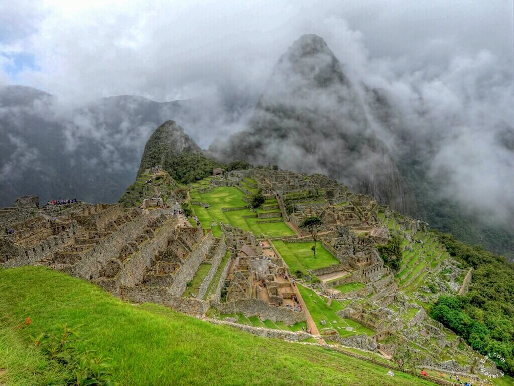
Machu Picchu, meaning old peak, stands 2,430 m (7,972 ft) above sea-level, in the middle of a tropical mountain forest, in an extraordinarily beautiful setting over a thousand feet above the Willkanuta river. It was probably the most amazing urban creation of the Inca Empire at its height; its giant walls, terraces and ramps seem as if they have been cut naturally in the continuous rock escarpments. The natural setting, on the eastern slopes of the Andes, encompasses the upper Amazon basin with its rich diversity of flora and fauna. Aguas Calietes lies on the Willkanuta river at an elevation of 2,040 m (6,690 ft). Upstream it is called by its Aymara name Willkanuta (“house of the sun” hispanicized Vilcanota). Within the La Convención Province the naming changes to Urubamba. A partially navigable headwater of the Amazon River, it rises in the Andes to the southeast of Cuzco. It was the rainy season and the river was a thundering waterway which could be seen all the way from the Machu Picchu sanctuary.
Discovery and First Views


Although the citadel is located only about 80 kilometers (50 mi) from Cusco, the Inca capital, the Spanish never found it and so did not plunder or destroy it, as they did many other sites. Over the centuries, the surrounding jungle grew over the site, and few outside the immediate area knew of its existence. Hiram Bingham was an American historian and lecturer at Yale University, although not a trained archaeologist. He organized the 1911 Yale Peruvian Expedition with one of its objectives to search for the last capital of the Incas. Bingham asked a Peruvian farmer and innkeeper, Melchor Arteaga, if he knew of any ruins in the area of Aguas Calientes. The next day, July 24, 1911, Arteaga led Bingham and Sergeant Carrasco across the river on a primitive log bridge and up the Huayna Picchu mountain. At the top of the mountain they came across a small hut occupied by a couple of Quechua, Richarte and Alvarez, who were farming some of the original Machu Picchu agricultural terraces that they had cleared four years earlier. Alvarez’s 11-year-old son, Pablito, led Bingham along the ridge to the main ruins. Bingham spent most of his life arguing that Machu Picchu and Vilcabamba were one and the same, a theory that wasn’t proved wrong until after his death in 1956. (The real Vilcabamba is now believed to have been built in the jungle about 50 miles west of Machu Picchu.) Recent research has cast doubt on whether Machu Picchu had ever been forgotten at all. When Bingham arrived, three families of farmers were living at the site.
Intipunku or Sun Gate


The Sun Gate also called Intipunku in Quechua was once a guardhouse that marked one of the principle entrances to Machu Picchu. The large stone enclosure features big windows and doorways, and once had a thatched roof. It is located at 2,720 meters (8,924 feet) above sea level, and 290 meters (951 feet) above the Urban Sector of Machu Picchu. It also has a series of terraces below the gate. Following an original Inca Trail, it takes approximately 90 minutes to hike to the Sun Gate from the Guardhouse at Machu Picchu. The Sun Gates of Machu Picchu boast a picture-perfect vantage point overlooking Peru’s most famous ruins. Tourists flock to this outcrop high in the Andes Mountains to enjoy the same view featured on virtually every postcard depicting the Machu Picchu citadel. Also known as Intipunku, the Sun Gates consist of two stones perched at a narrow passage in the crevice of the mountain just above Machu Picchu. The sun shines brilliantly through this portal each day when it rises, hence the name.
Guardhouse or Caretakers Cottages


The Guardhouse also known as the Caretakers Hut was a thatched roofed building constructed from fairly crude stones and featured 3 walls and one open long side. The Guardhouse was a building used by soldiers who guarded two main entrances to Machu Picchu. From the south there was the Inca Trail from Intipunku (the Sun Gate), which nowadays is the finish of the classic 4 days Inca Trail hike and from the west the entrance of the main Inca trail from Vilcabamba.
Agricultural Terraces


Machu Picchu is divided most easily into the agricultural terraces to one side and the city itself, protected by a wall and flanked by a long stairway. There is no evidence of any defensive walls on the site and more evidence that it was built as a sacred royal city and defended via other means. Skeletal evidence of its people indicates they personally defended the site and it is suggested that they were skilled at psychological warfare and strategically built the city on the sheer faced mountain top. The southern agricultural terraces were explored with Ground Penetrating Radar (GPR) to reveal a complex filling profile especially suited for agricultural use. The terraces of the city itself showed a different profile, filled with stone rubble, meant to provide stability for the structures above. The city at Machu Picchu was built in the classical Inca architectural style over a series of terraced foundations. The structures are laid out so that their functions echo the contours and form of their surroundings. The Sacred Valley region is surrounded by very high mountains. The sun’s rays don’t reach deep enough in the valley, which remain cooler in their bottoms. The mountain sides ensure more intense sunlight for longer time during the day. In some parts there is little space in the valleys, so the usage of steps actually increases the area available for agriculture.
Urban Terraces


The foundations of the city of Machu Picchu were considerably different than the terraces in the agricultural areas. The 700 or so terraces, have a high permeability, so the water goes down underground to be carried safely away. Terraces at Machu Picchu are fundamental to its longevity. Without terraces, the mountain would have slid terribly, so we see them primarily as the means for soil stabilization and support of buildings, aqueducts and/or trails. The engineer Kenneth Wright has estimated that 60 percent of the construction done at Machu Picchu was underground. Much of that consists of deep building foundations and crushed rock used as drainage. (As anyone who’s visited in the wet season can tell you, Machu Picchu receives a lot of rain).
Main Entrance and Main Stairway


The southeast part of the Urban District is where we find the Upper Sector (or Hanan Pacha, which in Incan cosmology means “the world of above” or heaven). It is also the place we find the only entrance designed by the architects to the entire Machu Picchu complex. This Main Gate is next to a huge stairway that stands parallel to the Dry Moat and the city’s Defensive Wall. It is a striking stone door, where strange holes have been cut into the stones on both sides. These might have been used to hold up a horizontal bar that could have been placed across the door for security. On the threshold, there is also a stone ring above the door that might have been the placement for another, vertical bar, whose purpose would have been to provide more security to the main gate’s door. The city of Machu Picchu is most often referred to as “citadel”… this makes us think of a fortress, which Machu Picchu is not. It wasn’t built for military scopes, but it does have a very well defendable location. It could be a good observation place, a retreat, but in no case a military city. Its isolation and the way it was planned and constructed clearly reflects a civilian use. American archaeologist, Gary Ziegler says that Machu Picchu was a religious sanctuary of the Incas and the even at the time of its completion, it was kept secret from other Incas as well. Machu Picchu’s stone steps are often completely carve out of a single piece of granite. Why the Incas chose this complex way of building the stairs is not known. Certainly with today’s eyes and minds, we can observe that the Inca stairs of Machu Picchu are more resistant over time, because fewer components are used. Machu Picchu has more than 100 stairs and some of them have over 100 steps. Interestingly, you can even find single-rock stairs in Machu Picchu. All stairs are made out of a single rock and they were never split.
The Quarry


What at first glance appears to be a jumble of boulders was probably a workshop where expert stonecutters practiced their trade. A recent theory proposes that the Inca Trail was a pilgrimage that concluded within the walls of Machu Picchu. If so, the quarry may have had a sacred meaning as a representation of the creation myth, in which the first Incas emerged after an underground journey. No one really knows how Machu Picchu was built but they know that the stones they used to build the city were said to be impossible to lift. The stones used were put on top of each other in a certain way that were very stable. They did not use any sort of mortar to hold the stones together. Most of the stones were fit so well that not even a credit card could go between them. Archeologist believed that the Inca would use ramps to move the boulders around Machu Picchu for construction. They also think that they would put the larger stones on smaller stones so that the smaller stones could act as rollers to move the larger boulders. The rocks they used to build were taken from granite rock. Historians assume that one of the main reasons they picked their location on a mountain was because it was near this rock quarry. This made moving rocks and boulders in Machu Picchu a lot easier, since it was nearby.The plateau on which the city was built was also the place where the construction materials were extracted. The rock quarry can still be found in the city of Machu Picchu. The majority of construction rocks are rather small, unlike Ollantaytambo and Sacsayhuamán.
Huayna Picchu


Many people don’t even know that one can climb the high mountain behind Machu Picchu. Most photos that you will see contain the high loaf-like mountain behind the Urban Sector, Huayna Picchu. The Incas built a trail up the side of the Huayna Picchu and built temples and terraces on its top. The peak of Huayna Picchu is about 2,720 metres (8,920 ft) above sea level, or about 360 metres (1,180 ft) higher than Machu Picchu. According to local guides, the top of the mountain was the residence for the high priest and the local virgins. Every morning before sunrise, the high priest with a small group would walk to Machu Picchu to signal the coming of the new day. The Temple of the Moon, one of the three major temples in the Machu Picchu area, is nestled on the side of the mountain and is situated at an elevation lower than Machu Picchu.
Summing Up

At the time of Columbus’ landfall on the New World, the greatest empire on earth was that of the Inca. Called Tawantinsuyu or “Land of the Four Quarters”, it spanned more than 4300 miles along the mountains and coastal deserts of central South America. The vast empire stretched from central Chile to present Ecuador-Colombia border and included most of Peru, Bolivia, Ecuador, northern Chile and northwestern Argentina (this is a land area equal to the entire portion of the United States from Maine to Florida east of the Appalachians). It exceeded in size any medieval or contemporary European nation and equaled the longitudinal expanse of the Roman Empire. Yet for all its greatness, Tawantinsuyu existed for barely a century. As always I hope you enjoyed the pictures, please leave a message.
[mappress mapid=”153″]
References:
Hiram Bingham Natgeo: http://ngm.nationalgeographic.com/1913/04/machu-picchu/bingham-text
Machu Picchu 360: http://www.machupicchu360.org
Unesco: http://whc.unesco.org/en/list/274
Machu Picchu: http://www.enjoy-machu-picchu.com/special-information-machu-picchu-engineering.php
Sun Gate: http://theonlyperuguide.com/peru-guide/machu-picchu/additional-hikes/sun-gate-inti-punku/
PBS Terraces: http://www.pbslearningmedia.org/resource/135c684f-d775-4992-91b8-13a01ff0edcf/incan-engineering-time-scanners-machu-picchu/
PBS: http://www.pbs.org/wgbh/nova/ancient/wright-inca-engineering.html
Inca Stone Fitting: http://www.davideandrea.com/personal/ideas/inca_stones/index.html
Construction Shows: http://constructionshows.com/machu-picchu-the-lost-city-part-1-city-planning/278306
Stone Masonry at Machu Picchu: http://michaelsheiser.com/PaleoBabble/2009/07/stone-masonry-and-engineering-at-machu-picchu-no-aliens-needed/
Natgeo: http://travel.nationalgeographic.com/travel/top-10/peru/machu-picchu/secrets/#close
Natgeo Map: http://ngm.nationalgeographic.com/2011/04/inca-empire/interactive-map