
I have decided to write several posts on the history of Ethiopia and Yemen because of their importance in ancient history and trade. I have not visited and given the political situation, may not ever do so, hence the pictures are drawn from the Internet. Please consider these posts as foundation articles, providing background for the really interesting stuff.
Today's Yemen, named Felix Arabia (Happy Arabia) by Ptolomy, at the southern tip of the Arabian Peninsula, is a land of lush valleys, sheer jagged cliffs that plunge dramatically into the Arabian Sea, white beaches and the vast, inhospitable stretch of desert known as The Empty Quarter. The western coastal strip, the Tihama, that hugs the Red Sea, looks like Africa, with its dense tropical forests and conical huts. In the eastern highlands, smoke drifts up from active volcanoes and hot springs bubble from the ground. This southern tip of the Arabian peninsula was one of the cradles of civilization although in fact the entire peninsula was once pastureland due to two humid periods from 33,000-21,000 and 8000-5000 BC. Some believe the proverbial Garden of Eden was located here. 'Planus' (Pliny the Elder) allocated a whole chapter in his book “Natural History” to Arabia Felix. In this chapter he talks about Sheba, Myrrh and incense production, and the caravans' route to Gaza. Agatharchides in 132 BC writes: “There is everything that can make you happy in Sheba. The people of Sheba are among the richest in the world. They trade in Arab and Indian goods which they took in caravans to the west. They have also huge ships crossing the Indian Ocean.”
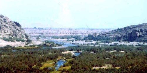


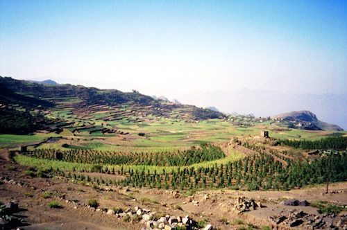
As the water became more sparse the inhabitants built impressive irrigation projects and terraced fields in the Land of the Two Paradises, Ardh al-Jannatayn, another name the ancients used for Felix Arabia. The inhabitants built irrigation structures here as early as the 3rd millennium BC, but the great Ma'rib dam, large sections of which are still visible today, was by far the largest and most impressive, started between 1750 and 1700 BC. The Marib Dam shown above was built over time and from the lake that developed behind the dam, they developed an irrigation system that watered about 25,000 acres. Faced with meticulously cut stone blocks, the dam spanned an 1,800-foot gap cut through the Balaq Hills by the Wadi Adhanah, and rose 25 feet above the watercourse, according to modem estimates. Awed ancient writers gave greater dimensions – 100 feet high and over 5,000 feet long – but they apparently confused the dam proper with its extensive associated irrigation system.
According to inscriptions, the dam was heightened in the 7th century BC by a ruler named Sumhu' Alay Yanuf and his son Yatha'-Amar Bayyin, but it was maintained, for centuries after, by successive generations of skilled Sabaeans and, later, by the kings of Himyar, a civilization that succeeded the Sabaeans as a potent force in South Arabia. It finally broke and flooded in 575 AD, resulting in a mass exodus from the area. There are also other important ancient dams in Yemen such as the Dam of Jufaynah, the Dam of Kh?rid, the Dam of A?ra’ah, the Dam of Miqr?n and the Dam of Yath’?n. In December 1986 a new 125-foot-high (38-meter) earth dam was officially inaugurated, transforming 45,000 acres of desert into productive farmland.
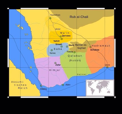
Between the 8th to 12th century BC and the 6th century AD, South Arabia was dominated by six main states which rivaled each other, or were allied with each other and controlled the lucrative spice trade: Saba', Ma'?n, Qatab?n, ?a?ramawt, Aws?n, and ?imyar. They were located around the strip of desert called ?ayhad by medieval Arab geographers, which is now named Ramlat al-Sab`atayn. The dates and geographic locations of these places are subject to revision as archeological investigation has been hampered by the political instability of the region. Although the kingdoms never formed a political or ethnic unity, the most powerful of all these city-states was Saba', which slowly expanded its political influence to include all the major kingdoms of the south. Under its most famous ruler, Karib'il Watar, who reigned about 700-680 BC, the Sabaean kingdom stretched over most of southwest Arabia. During the 3rd century CE, the South Arabian kingdoms were in continuous conflict with one another. The ?imyarite Kingdom conquered the the kingdom of Saba' in the 1st century BC and took Raydan/Zafar for its capital instead of Ma’rib. Its ruins still lie on Mudawwar Mountain near the town of Yarim. They lasted until about 300 AD when a slow decline occurred in the entire region.
Saba's riches came from its role as a trans-shipment point for Eastern (India, Southeast Asia and China) luxury goods being traded to the West and from the collection and sale of two rare and expensive aromatic resins – frankincense and myrrh, for which the ancient world had a nearly insatiable appetite. They were used by the ancient Egyptians in embalming, were burned as offerings to the pagan gods of East and West, were valued as medicines from first-century Rome to 11th-century Persia, and perfumed the state occasions of royal and imperial courts throughout the known world well into the early Middle Ages. Yet they grew, almost exclusively, in Southern Arabia – whose inhabitants told fabulous tales about the dangers and difficulties of collecting them in order to deter competitors, and were a vital factor in the prosperity that earned the area the name Arabia Felix – Happy Arabia. Don't worry, lots more to come on this subject.

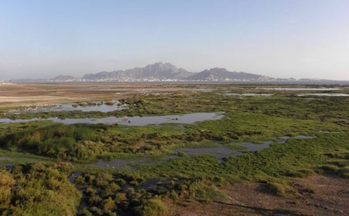
The Rub' al Khali or Empty Quarter is the largest sand desert in the world, encompassing most of the southern third of the Arabian Peninsula, including most of Saudi Arabia and areas of Oman, the United Arab Emirates, and Yemen. Along the middle length of the desert there are a number of raised, hardened areas of calcium carbonate, gypsum, marl, or clay that were once the site of shallow lakes. These lakes existed during periods from 6,000 to 5,000 years ago and 3,000 to 2,000 years ago. The lakes are thought to have formed as a result of “cataclysmic rainfall” similar to present-day monsoon rains and most probably lasted for only a few years. Desertification has increased through the millennia. Before desertification made the caravan trails leading across the Rub' al Khali so difficult, the caravans of the frankincense trade crossed now virtually impassable stretches of wasteland, until about AD 300. Geologically, the Empty Quarter is the most oil-rich site in the world.
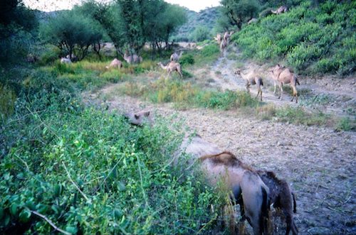
With the domestication of the camel in the 11th century, the southern Arabians could effectively exploit the region's greatest natural resources, frankincense and myrrh, which from the earliest historical periods were much prized and sought after. The purest and most abundant sources of frankincense and myrrh were in southern Arabia and Somalia/Ethiopia (Punt), just across the Red Sea. We hear of the Sabeans during the reign of the powerful Assyrian king Sargon II (721-705 B.C.E.). In a series of inscriptions detailing Assyrian military successes, there is specific mention of:
“Pir'u, the king of Musru, Samsi, the queen of Arabia, It'amra, the Sabean,-the(se) are the kings of the seashore and from the desert-I received as their presents gold in the form of dust, precious stones, ivory, ebony-seeds, all kind of aromatic substances, horses (and) camels.”
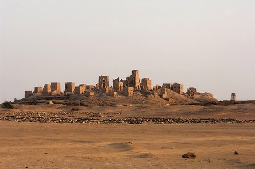

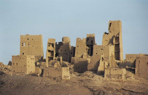
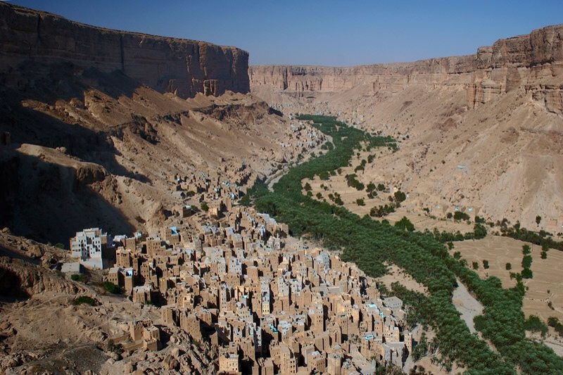
Old Marib, founded in about 1,200 BC, was once a powerful political capital and still bears the markings of its past grandeur. It is an ancient city and was the residence of the rulers of the state of Saba; its ruins lie northeast of the city of Sana, in the Yemen Arab Republic. It has the multistory buildings common in Yemen but unusual elsewhere in the near east. It had a rectangular layout and was surrounded by a stone wall; the rulers’ palace was located inside the city. Numerous date palm plantations lay outside the walls. It’s strategic position lends itself to its important role in history, as it controlled the ancient incense routes. It was a meeting point for caravans coming from the Qana port on the Arabian Sea coast, crossing the Wadi Hadhramout. The site of Ancient Ma'rib was largely abandoned during the 20th century. Although a small village remains, the multi-story mud-brick buildings of the historic city are largely in ruins, due mainly to bombing in the 1962 civil war. The modern city of Ma'rib is located about 3.5 kilometers north of the center of the ancient city. It is believed that the present village was built over the ruins of the Sabaean historical palace (Salhin). In the ancient city, there are four temples, two in the northern part, and one in the southern part. The huge stone columns nearby the well represent the fourth temple.

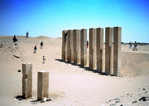
Throne of Balquis (Bar’an Temple) Arsh Bilqis (Yemen), the Throne of Bilqis is the second most important temple in Marib. A line of five elegant symmetrical pillars, also known as the Almaqah or Sun Temple, was built towards the end of the eighth century BC. This has now been extensively exacavated by German archeologists, uncovering a broad temple floor surrounded by steps and inscribed marble plinths.

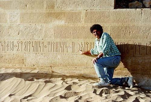
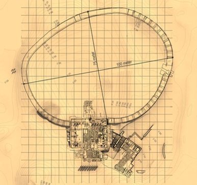
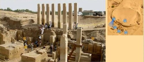
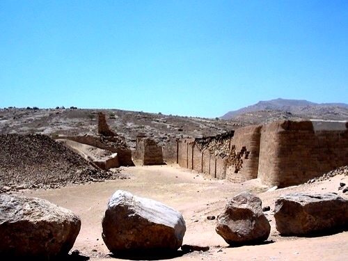
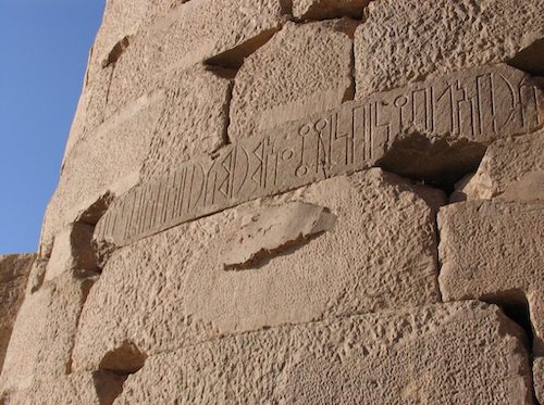
The Mahram Bilqis, also known as the Awam Temple, is the largest pre-Islamic Sabaean temple in Yemen, if not the world. It was a holy place, the mecca of its day, dedicated to the Sun God, Almaqah, as revealed in the inscriptions adorning its massive wall. These South Arabic messages have been dated to the 7th century BC and can still be seen today on the unique, oval-shaped wall. The eight pillars that formed the propylon at the entrance of the temple, and several smaller pillars that presumably lined a courtyard, are still visible. A reconstruction of the temple suggests that it was similar in form to the Bar’an Temple in Marib’s southern oasis.
In 1951 the American Foundation for the Study of Man (AFSM), led by its director and founder Wendell Phillips, excavated the peristyle hall of the Ma?ram Bilqis but was cut short due to lack of security, leaving all his research behind. His sister Merilyn Phillips continued his work from 1998-2006 when security again became a problem. Our knowledge of Saba and its patron god Ilmaqah (or Almaqah) comes from these archaeological expeditions and excavations conducted in the last 150 years. This is an unbelievably massive undertaking; the site is at least four square football fields. I strongly suggest you visit the AFSM Interactive Viewer to see the actual site; their perseverance in the face of tremendous obstacles is inspiring. The hypothesis of Ditlef Nielsen in 1920 of a moon and Venus god in addition to a sun god has been disproved, the Sabaean god was the sun god (go here for the proof). There is apparently an ancient library here if the archeologists are ever allowed to excavate.
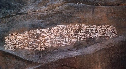
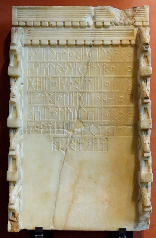
The body of source material for Old South Arabia is sparse. Apart from a few mentions in Assyrian, Persian, Roman and Arabic sources, as well as in the Old Testament, which date back to the 8th century BCE right up to the Islamic period, the Old South Arabian inscriptions are the main source. These Sabaean inscriptions appear suddenly in the archeological record in about the 10th century BC. Zab?r is the name of the cursive form of the South Arabian script that was used by the ancient Yemenis (Sabaeans) in addition to their monumental script, or musnad. The earliest inscriptions in the alphabet date to the 9th century BC in Akkele Guzay, Eritrea and in the 10th century BC in Yemen. There are no vowels, instead using the mater lectionis to mark them. In Ethiopia it evolved later into the Ge'ez alphabet, which, with added symbols throughout the centuries.
Musnad al-Shamali (North Arabic Thamudic script) spread out around the first millennium BC through northern Arabia, and from this developed the Lihyanite, Safaitic and Aramaic writing systems, which flourished in the north of Arabia around the middle of the first millennium BC. From Aramaic Nabataean script and from Nabataean, Arabic writing developed (disputed).

The domestication of animals and the rise of agriculture which characterizes the neolithic, is thought to start around 6,000-4,000 BC in the Tihama, along the Red Sea in Yemen. Extensive bronze age remains have been found in several areas of Yemen, notably on the plateau of al-Jawl, the fertile Wadi Hadramawt which cuts through it, the Tihama and the highlands. Since 1994, the joint German-Russian expedition has provided evidence for an unknown pre-Islamic archaeological complex in the hinterland of Aden (Republic of Yemen). At present, this Sabir Culture appears restricted to the southern Saudi Tihama and to Yemen’s coastal plains along the Red Sea and the western Gulf of Aden. The remains in Sabir and Ma'layba have been 14C dated to about from about 2000-1000 BC, overlap with Sabaean states is not known.
The famous port city of Aden is seen above in the distance. The peak of Jabal Shamson is seen in the center while the bay of Aden is between.
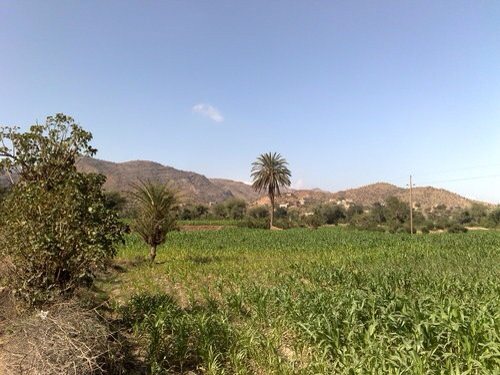
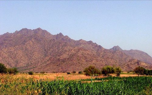
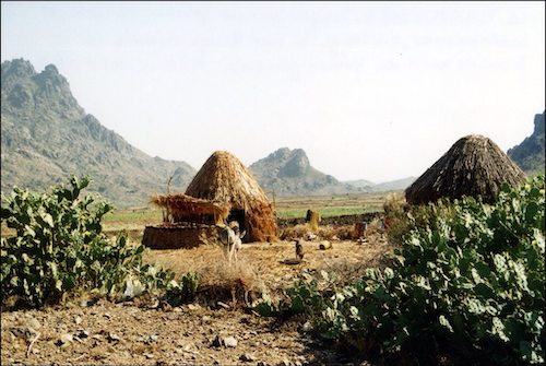
The Tihâma, a narrow and flat coastal plain, makes up the western Red Sea coast of Yemen. Lying across from the coastal plain of the Horn of Africa to its west and adjacent to the western escarpment that ascends steeply to the highland central plains of Yemen to its east, the Tihâma lies at the balance of two divergent landscapes, the sea and the highlands. It is mostly dry but humid and hot with areas of jungle, the conical huts are characteristic of the area.

In the sixth millennium BC, the mangrove forests that characterized the deltaic littoral provided a diverse flora and fauna for foragers who inhabited its fringes. The material evidence demonstrates a dietary reliance on mangrove dwelling molluscs, namely Terebralia palustris, and to a lesser degree on fish. The period between the seventh and fourth millennia BC witnessed a gradual drying of the climate, a progressive decrease in sea levels and a recession of the mangrove habitats that supported the early Holocene coastal communities. By the late prehistoric period, sites retained the fourth millennium BC site dispersal strategy and began to cluster into conglomerate settlements along the littoral and the riverbanks. The transformations to the physical and cultural landscape of the Tihâma by the third millennium BC have been shown to reflect a concomitant process of climate change, intensified land-use. Seven megalithic sites in total have been documented in the Tihâma from about the 3rd millennium.
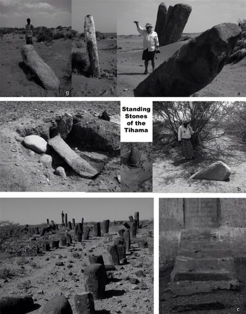
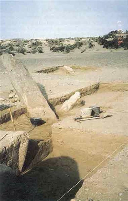
The excavation of the front of one monolith unearthed two copper plates, two ax heads, two points of spears, dating from 2500 BC. In the plain of Tihama there have been discovered 126 sites of 30 square km. These are mostly cluster shells and mounds of broken pottery. The shells are composed of clusters remains of shells Terebralia palustris, a mangrove snail, mainly used as bait and as feedstock for the manufacture of lime. Many bones of horses and Caprinae, demonstrates the practice of farming or at least pastoralism. There are also bits of pottery and fragments of bronze. The mass shells are dated 7th millennium and ceramic shards and bones of the third millennium BC. There are the standing stones of Hamili. But also several stone alignments of more than a kilometer, 1 to 3 meters high, perfectly tapered at the foot of Jabal al-Mahandar North of the city of Zabid, there is still a site of standing stones.

The ancestors, the Caprinae, of the modern sheep and goats (both rather vague and ill-defined terms) are thought to have moved into mountainous regions – sheep becoming specialized occupants of the foothills and nearby plains, and relying on flight and flocking for defense against predators, and goats adapting to very steep terrain where predators are at a disadvantage.
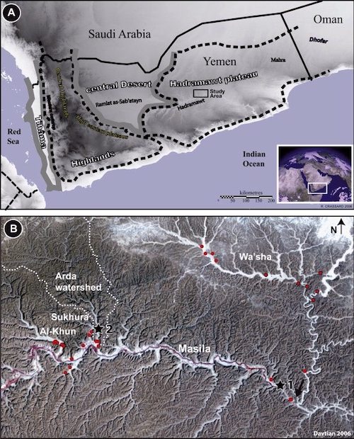
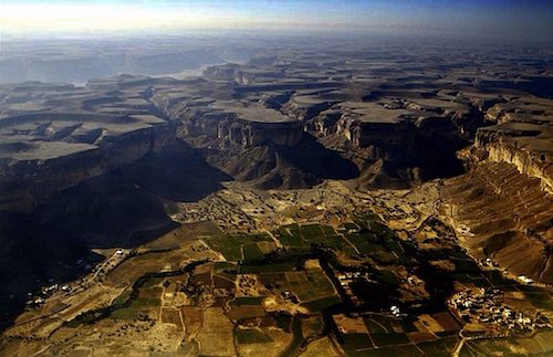
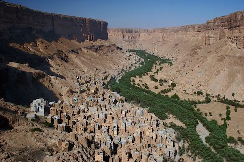
The fertile Wadi Hadramawt has been the subject of several investigations. Humid periods have been found until the beginning of the first millennium BC (5.9–5.3, 4.8–4.5 and 4.0–2.7 thousand years ago). River behavior also impacted Neolithic and early Bronze Age settlement systems in this lowland area, as phases of floodplain stability favour Neolithic site location.
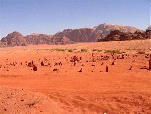
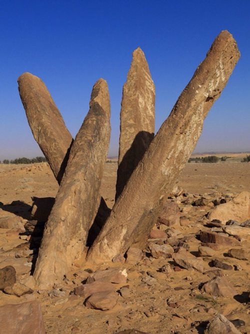
In the Wadi Wa’sha, funerary remains and traces of habitat surveys are dated from the late fourth millennium to the mid third millennium BC. Tombs have been found in addition to circular towers, tombs wall, mounds, cists and dolmens. The megaliths are trapezoidal form structures and include alignments trilithons. One of the most important site trilithons, listed HDOR 592, has over fourteen alignments that span over 300 m long Small circular structures associated with these alignments The orientation of the alignment follows that of the bed of the Wadi.
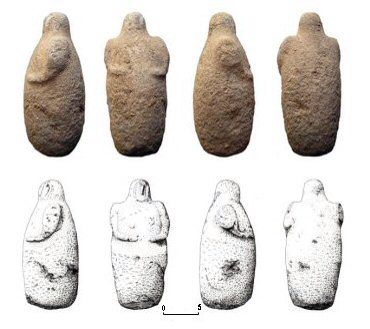

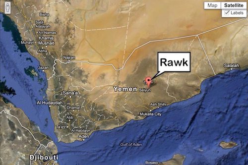
In 1989, at Rawk, the erosion caused by the overflowing of a seasonal riverbed (Sha'b) revealed three anthropomorphic statuettes placed between two upright stones. In 2004, the inhabitants of the same village discovered another statuette at the same location. The director of the Sayun Museum then authorised the French “Jawf-Hadramawt” expedition to study the structure in which these objects were found. Apart from a votive deposit, a rescue excavation also unearthed a set of grave goods. The Rawk monument appears to be one of the first in Yemen to be discovered and attributed to the fourth millennium BC (3499-3198 BC) Even though its preservation is incomplete, it is a unique building that has yielded important elements of information.

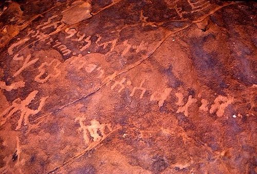
Standing Stones are also found in the northern desert of Saudi Arabia. Al-Rajajil is a barren plain with groups of standing stones which are about 4000 or 5000 years old. The tall thin stones, up to 3 meters high, have Thamudic inscriptions and are lined up to sunrise and sunset. Called al-rajajil (“men”) today, the pillars appear to the casual observer to be randomly placed, although a bird's-eye view shows that they are placed in roughly parallel east-west lines. Around Sakaka, Saudi Arabia.
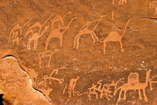
Jubbah is located in the region of Hail, 350 km north of Riyadh The town was built there over 7000 years. Jubbah, Sakaka and Al-’Ula petroglyph sites are the most famous of Saudi Arabia. At Jubbah the first drawings and inscriptions carved on rocks dating from 5,500 years ago and ranged up to 3500 years BC. At that time Jubbah was near a lake. The drawings reveal a fauna composed of ibex, oryx, antelope from Arabia.
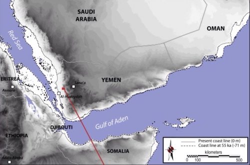
“It has been suggested that the groups who colonized South Asia rapidly expanded from South and East Africa along the Arabian coastlines around 60 ka BP (60,000 years ago), bringing with them a modern behavioral package including microlithic (stone) backed tools, ostrich-eggshell beads or engraved fragments. One new site is the study's led by Anne Delagnes of France's Université Bordeaux, Shi'bat Dihya, located along the Wadi Sudud. Excavating down to a level dating to perhaps 63,000 years ago, when the region was quite arid, the team found some “5,488 artifacts” — Stone Age blades, pointed blades and pointed flakes, nearly an inch long or longer, as well as the bones of 97 animals, mostly cows, horses, pigs and porcupines. Most likely on a seasonal basis, South Arabian populations spread throughout the Empty Quarter in the Summer exploiting animals and plants associated with the lakes and streams. In the winter they retreated to streams, lakes, and springs south and west of the sand desert. The people of the period did not see the Rub al Khali as a hindrance to crossing from South to central Arabia.

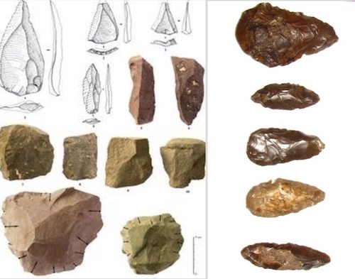
Bifacial Neolithic tools and weapons Phase I (6500-5000 BC) and II (5000-3500 BC) have been found in profusion over the length and breadth of Arabia. Many have been found along the Rub al Khali fossil lakes. They represent a vast array of hunters focussing on such varied game as equids, bovids, oryx, antelope, wild sheep and goats, and ostrich. They mined their flint from rich sources in many Arabian localities.
Since this is such a long post, I need to summarize the post and the subjects we will focus on in the future. The history of Yemen for historical interest can be placed in four categories. The first is the migrations of the first humans at about 300,000 and 60,000 BC. The logical passage from Africa to Eurasia by Homo Sapiens is either the “Levantine corridor” along the Mediterranean Sea or the narrow crossing between Yemen and Djibouti , called the Bab al-Mandeb Strait (the “Arabian corridor”). Industries resembling the East African stone industries are unknown in the Levant. The second is the Neolithic period from around 10,000 BC to 3500 BC and the relation to Africa, Ethiopia, India and the Levant. The development of boats, domestication of animals (particularly horses and cattle) and sea travel is in this period. From 3500 and 1000 we see the rise of organized states, but without the usual written language of the Bronze Age, the age of “Punt”. This period is characterized by a favorable climate with mangrove forests along almost the entire Red Sea. Finally we have the spice and trading Empires of about 1200 BC to 400-500 AD, commonly referred to as the kingdom of Sheba with the domestication of camels and the introduction of written language. As you can see, ancient Yemen is an extremely interesting place, unfortunately poorly documented because of political instability.
References:
The Marib Dam: http://nabataea.net/marib.html
New Marib Dam: http://www.saudiaramcoworld.com/issue/197802/a.dam.at.marib.htm
Marib Dam: http://www.traveladventures.org/continents/asia/marib05.shtml
The Sabeans: http://www.bahaistudies.net/asma/sabaeans.pdf
The Road to Ubar: http://www.amazon.com/The-Road-Ubar-Finding-Atlantis/dp/0395957869
German Archeology Marib: http://www.dainst.org/en/event/german-archeological-institute-makes-spectacular-archaeological-discovery-ancient-sabaean-town?ft=all
AFSM Mahram Bilqis: http://www.afsm.org/tour2/Awam-N2/awam_Awam3-N.asp
Sabir and Ma'layba: https://journals.uair.arizona.edu/index.php/radiocarbon/article/download/3878/3303
List of Rulers of Saba: http://en.wikipedia.org/wiki/Rulers_of_Sheba
Ilmaqah: http://www.islamic-awareness.org/Quran/Contrad/External/sheba.html
Smithsonian Arabian Writing: http://www.mnh.si.edu/epigraphy/e_pre-islamic/preislamic.htm
Ancient Scripts: http://www.ancientscripts.com/s_arabian.html
Stones of Tihâma: http://remmm.revues.org/4723
Anthropomorphic Stones: http://antiquity.ac.uk/projgall/steimer/index.html
Earth History: http://earthistheaim2.wordpress.com/
Rivers of the Hadramawt watershed (Yemen) during the Holocene: Clues of late functioning: http://www.sciencedirect.com/science/article/pii/S1040618211006227
Earth is the Aim: http://earthistheaim.wordpress.com/
Inland human settlement in southern Arabia 55,000 years ago. New evidence from the Wadi Surdud Middle Paleolithic site complex, western Yemen: http://www.sciencedirect.com/science/article/pii/S0047248412000565