
I thought that I would write an introductory post on the geography and history of the Cape Peninsula, mainly because while everyone has heard of Cape Town and the Cape of Good Hope, knowledge usually ends at recognition. The Cape Peninsula (Kaapse Skiereiland) is a rocky and hilly peninsula that juts out into the Atlantic Ocean at the south-western extremity of the African continent. At the southern end of the peninsula are Cape Point and the Cape of Good Hope. On the northern end is Table Mountain, overlooking Cape Town, South Africa. The peninsula is 32 miles (52 km) long from Mouille point in the north to Cape Point in the south. The Peninsula has been an island on and off for the past 5 million years, as sea levels fell and rose with the ice age and interglacial global warming cycles of, particularly, the Pleistocene. The last time that the Peninsula was an island was about 1.5 million years ago. Soon afterwards it was joined to the mainland by the emergence from the sea of the sandy area now known as the Cape Flats. The towns and villages of the Cape Peninsula and Cape Flats now form part of the City of Cape Town Metropolitan Municipality. One of the many reasons that travelers choose to visit Cape Town is its abundance of scenic beauty and natural attractions. The city itself is situated between the Atlantic Ocean and Table Mountain, one of the world’s Seven Wonders of Nature. Table Mountain’s iconic plateau forms the dramatic backdrop of the city and is a must-see for visitors. On the peninsula, there are beaches, penguins, seals, ostriches and lots of hiking trails with beautiful scenery. For me, the famous fynbos with it’s many plants and flowers were a major draw along with the history and all of the above.
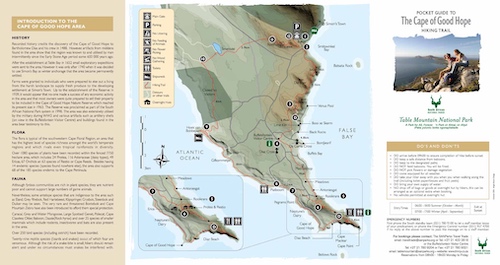
Cape of Good Hope in Perspective
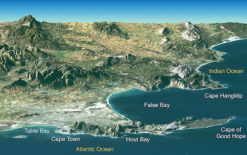
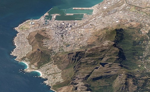
Cape Town and the Cape of Good Hope, South Africa, appear in the foreground of this perspective view generated from a Landsat satellite image and elevation data from the Shuttle Radar Topography Mission (SRTM). The city center is located at Table Bay (at the lower left), adjacent to Table Mountain, a 1,086-meter (3,563-foot) tall sandstone and granite natural landmark. False Bay is the large bay to the south (right) of Cape Town, just around the Cape of Good Hope. It is one of the largest bays along the entire South African coast, but nearby Cape Town has its harbor at Table Bay. False Bay got its name because mariners approaching Cape Town from the east would see the prominent bay and falsely assume it to be the entrance to Cape Town harbor.
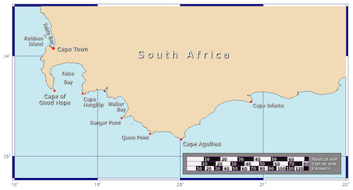
People often mistakenly think the Cape of Good Hope is the southernmost point of Africa. But the southernmost point is actually Cape Agulhas, located some small distance to the southeast. In sailing, the great capes are three major capes of the continents in the Southern Ocean — Africa’s Cape of Good Hope, Australia’s Cape Leeuwin, and South America’s Cape Horn. Historically, Cape Agulhas has been known to sailors as a major hazard on the traditional clipper route. It is sometimes regarded as one of the great capes. It was most commonly known in English as Cape L’Agulhas until the 20th century. The town of L’Agulhas is located near to the cape.
The Cape of Good Hope is sometimes erroneously identified as the meeting point of the Atlantic and Indian Oceans. However, according to the International Hydrographic Organization agreement that defines the ocean boundaries, the meeting point is at Cape Agulhas, about 200 kilometres (120 mi) to the southeast and the most southerly tip of the African continent. The west coast of the Peninsula is referred to as the “Atlantic Coast”, “Atlantic Seaboard” or west coast, but the eastern side is generally known as the “False Bay Coast”. Mariners have long considered the waters off Africa’s southern tip to be treacherous. After decades of failed attempts to navigate around the continent, Portuguese explorers took to calling one of its southerly promontories the Cape of Storms. (It was later renamed the Cape of Good Hope.) Cape Agulhas, Africa’s southernmost point, is Portuguese for Cape of Needles. Historians think the name may be a reference to the needle-like rock formations and reefs along its coast.

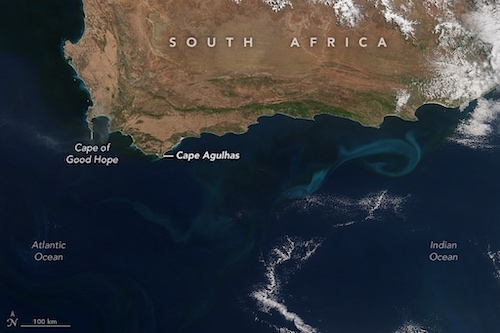
The convergence of two ocean currents—one warm and one cold—in the shallow waters of Agulhas Bank produces turbulent and unpredictable waters. Warm water arrives from the east on the fast-moving Agulhas Current, which flows along the east coast of Africa. Meanwhile, the cooler, slower Benguela Current flows north along Africa’s southwestern coast. That means navigating around the tip of South Africa requires mariners to sail against ocean currents on both sides of the continent. In the Agulhas region around South Africa, part of the return flow of surface and intermediate waters from the Indian Ocean leaks into the Atlantic, providing heat and salt that is moved towards the deep-water formation regions of the subpolar and subarctic North Atlantic. The Agulhas Current flows poleward as a western boundary current and abruptly turns eastward into the Agulhas Return Current.

The instability and churning does have one benefit. As water masses stir the ocean, they draw nutrients up from the deep, fertilizing surface waters to create blooms of microscopic, plant-like organisms (phytoplankton) in the open ocean. The phytoplankton feed a robust chain of marine life that makes Agulhas Bank one of the richest fishing grounds in southern Africa. If you want to see just how rich in life these waters are, I highly suggest the Netflix film “My Octopus Teacher”, shot near Simon’s Town in False Bay. Not only is it at an exemplary nature film but the lush underwater footage really underscores the rich diversity of marine life in this area.
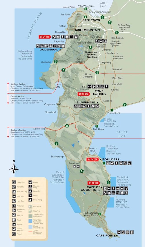
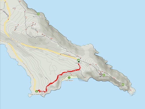
Cape Peninsula Tourist Map
After the establishment of a colony at Table Bay in 1652 small exploratory expeditions were sent to the surrounding areas. In 1743, dangerous winter storms prompted the Dutch East India company to relocate their anchorage from Table Bay (below Table Mountain) to Simon’s Bay (in the crook of False Bay) between May and October. A need arose for nearby farms to provide supplies to the harbor, so land was divided and leased to Dutch emigrants. Farms were granted to individuals who were prepared to eke out a living from the harsh landscape to supply fresh produce to the developing settlement Simon’s Town. Up to the time of the establishment of the Reserve in 1939 it would appear that no-one made a success of any economic activity in the area and that most owners were quite prepared to sell their property to be included in the Cape of Good Hope Nature Reserve which reached its present size in 1963. The reserve was proclaimed as part of the South African National Park system in 1998. The area was also extensively utilized by the military during WW2 and various artifacts such as artillery shells (on view at the Buffelsfontein Visitor Center) and buildings found in the area bear testimony to this.
Buffelsfontein Lime
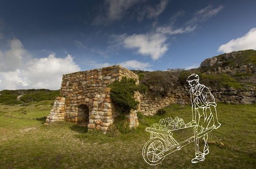
By the early 1800s, the southern Cape Peninsula was divided into about half a dozen main farms, and five smaller erfs. Buffelsfontein was the largest tract of land, straddling the entire southernmost part of the promontory. Here we use the term farm loosely. With the exception of the banks of the Klaasjagers River that constitute the northern boundary of Cape Point, the land of the Cape of Good Hope is not at all suited to farming. Cattle did not thrive on the fynbos bushes of the peninsula and large scale crops did not take to the shallow, sandy soil. One historian tell us that the laborers on these early farms “described themselves as gardeners” rather than farmhands. But there was one resource that was both extremely valuable in those days and particularly abundant in Cape Point: sea shells. Burning piles of sea shells for a long time (seven days) turns them into a type of calcium powder which, when mixed with water, creates a whitewash or a lime paste. Lime was used to coat the exterior of buildings and as mortar or cement. Lime became a commodity that determined the pace with which the entire Cape colony could grow. The farmers of Cape Point may not have been able to supply sufficient livestock or vegetables for Simon’s town, but they had large quantities of valuable lime. Sadly for the “farmers”, sea shells are not the most efficient source of lime and by the 20th century, the business was all but bankrupt.
Table Mountain
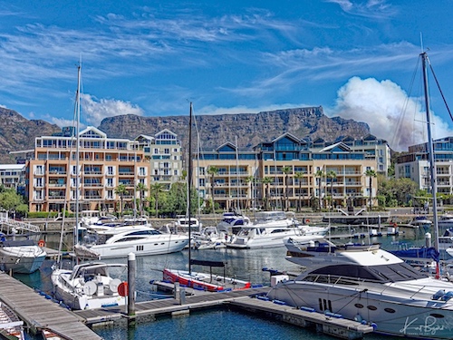
The main feature of Table Mountain is the level plateau approximately three kilometres (2 mi) from side to side, edged by impressive cliffs. The plateau, flanked by Devil’s Peak to the east and by Lion’s Head to the west, forms a dramatic backdrop to Cape Town. Table Mountain forms the northern part of the Table Mountain National Park. To convey a sense of the unique environment on the Cape Peninsula, I have included photography of some of the more recognizable features when driving.
Hout Bay
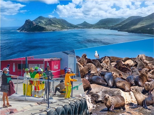
Hout Bay is a seaside suburb of Cape Town in the Western Cape province of South Africa. It is situated in a valley on the Atlantic seaboard of the Cape Peninsula, 12 miles (20 km) south of the Cape Town Central Business District. It is best known by tourists for the colony of Cape Fur Seals on Duiker Island just outside the bay.

Situated against the mountainside in Hout Bay overlooking the harbour, is the tallest structure on Karbonkelberg – The Lichtenstein Castle. Reyneir Fritz, a German-born Cape Town businessman, built his Lichtenstein Castle Replica in Hout Bay after a visit to the land of his ancestors. He saw the castle in Germany and wanted one for himself. On returning to South Africa, the owner/builder created his fantasy family home. He started building in 1986 and in 1998 it was completed, He eventually turned it into a guest house before dying there. Some time after his death, his widow sold it to an overseas buyer. Allegedly haunted, the castle is one of the area’s most popular attractions. In 2012, the castle was sold for 23 million Rand to a Russian business man. The castle is modeled on the original in Germany. In 1826, German poet and patriot Wilhelm Hauff published his book Lichtenstein, in which the castle, the book’s namesake, played a major role. King Frederick’s cousin, Count (later Duke) Wilhelm von Urach, a German patriot, who was very interested in medieval history, art, and architecture, was so inspired by the book that he purchased the estate. Construction of the New Lichtenstein Castle began in 1840 and used the ancient foundations of the castle of 1390. It stood up to three stories tall, with a curtain wall and courtyard to complete the castle complex and was completed in 1842. In this case, fact is stranger than fiction. The venue is rented out for weddings.
Chapman’s Peak Drive
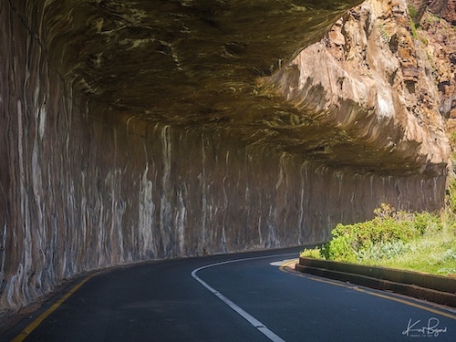
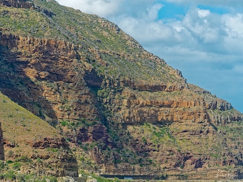
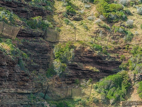
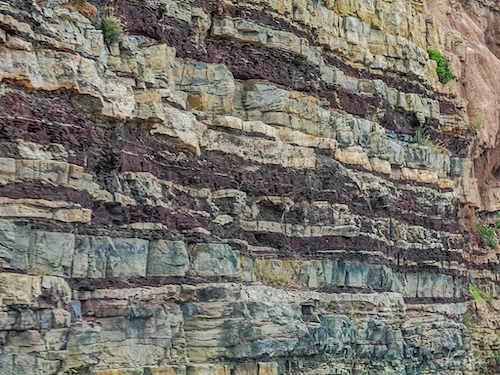
Chapman’s Peak Drive twists along the Atlantic coast between Noordhoek and Hout Bay with sheer drops to the sea below and towering mountains rising above. Thank goodness for the many pull offs to enjoy the view. First opened in 1922 then closed in the 90s after a rockfall caused death, it has reopened in 2005 with some added protection for motorists and bicyclists. I love these curvy roads even driving on the left. If you are a geologist visiting Cape Town, you absolutely have to go on the Chapman’s Peak Drive. The reason is simple: the road follows a spectacular nonconformity between ~550 million year old Cape Peninsula granite and ~450 million year old sandstone of the Table Mountain Sandstone Group. The basal (bottom-most) layer of this sandstone group is called the Graafwater. The Chapman’s Peak road was built by carving out the cliffside into the softer sandstones; the road itself rests on top of the harder granite.
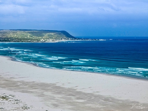
Noordhoek Beach
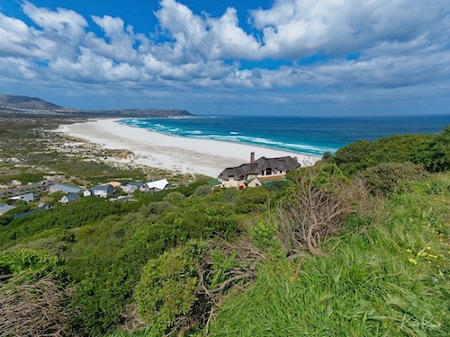
Noordhoek is a seaside town in the Western Cape, South Africa, located below Chapman’s Peak on the west coast of the Cape Peninsula and is approximately 35 kilometres (22 mi) to the south of Cape Town. The name “Noordhoek” was taken from Dutch and literally means “north corner”. It is best known for its shoreline and its long, wide, sandy beach, which stretches south to the neighbouring village of Kommetjie. Near the southern end of this beach is the wreck of the steamship “Kakapo”, which ran aground in 1900, when the captain mistook Chapmans’ Peak for the Cape of Good Hope and put the helm over to port.
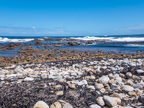
Kommetjie
Kommetjie (Afrikaans for “small basin,” approximately pronounced cawma-key) is a small town about halfway down the west coast of the Cape Peninsula, at the southern end of the long wide beach that runs northwards towards Chapman’s Peak and Noordhoek. If you look closely at the above photo, you can see the Slangkop Lighthouse at the rocky tip of the coast.
Slangkop Lighthouse

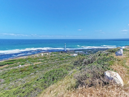
The Slangkop Lighthouse is located just beyond the town of Kommetjie on a rocky, unpopulated section of the peninsula. Construction was due to be completed in 1914 and a brass sign was commissioned for this date, but due to the First World War the lighthouse was not completed until 1919, although definitely in use before that date, e.g. noted in the log of HMS Himalaya on 19 July 1917. The lighthouse was inaugurated on 4 March 1919. The white circular iron tower stands 108 feet (33 m) high. You can head down the boardwalk trail nearby which heads all the way back around to Kommetjie and offers stunning views of the ocean. Keep in mind that it can get super windy by the lighthouse (especially during the winter months) and the rocks can be particularly slippery.
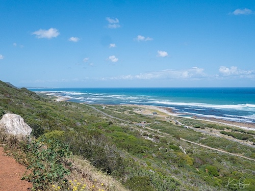
Misty Cliffs and Scarborough
Misty Cliffs, seen to the left, is a little village that lies on the mountain and on the beach, divided only by Main Road, between Kommetjie and Scarborough, roughly an hour from Cape Town. Misty Cliffs has acquired its name for its, rather obviously, misty cliffs – it overlooks the wild and tempestuous sea, and is renowned not only for incredible days and beautiful beaches, but also for windy and wet days, depending on the season. Scarborough, seen further in the distance, was designated as a conservation village in April 1996. It was defined as “a residential area of limited extent, surrounded by a conserved natural landscape, committed to reverse past environmental damage and to avoid future environmental impacts.”
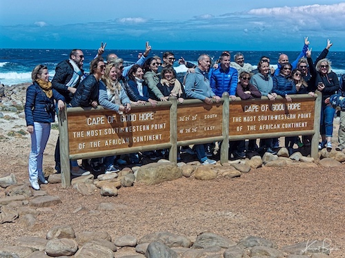
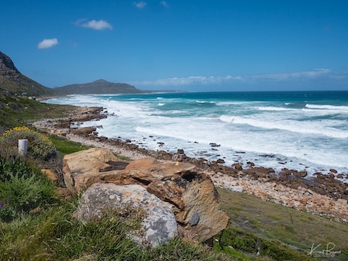
Cape of Good Hope
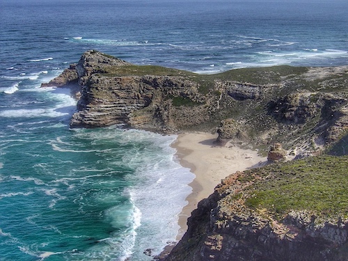
I must be honest, probably like much of the world, I was unaware that the peninsula ended in two capes and that the lighthouse was not on the Cape of Good Hope but instead on Cape Point. There is a beautiful trail between the two capes however. The Cape of Good Hope: Cape Point Connector Trail is a 1.9 mile very busy out and back trail located at the end of the Cape Peninsula that features beautiful wild flowers and is good for all skill levels. The trail is primarily used for hiking, walking, nature trips, and bird watching. A bit rocky but the biggest challenge is the wind. Dassie Beach is beautiful and the water isn’t as cold as one would think but then again the wind blowing the sand against you can be distracting. All said, the views along this trail are outstanding and well worth dealing with the wind.
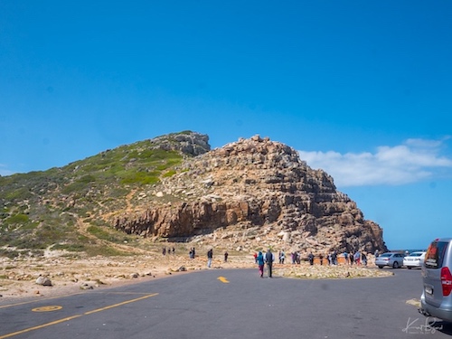
Cape Point
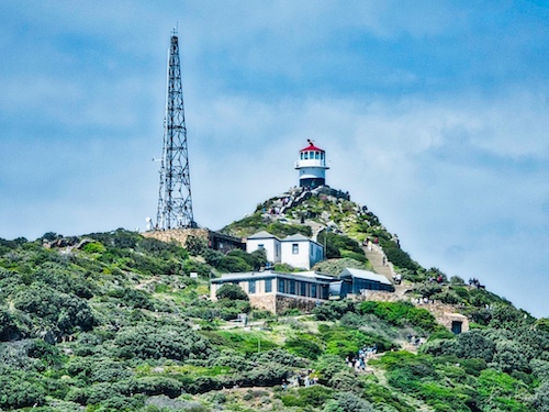

The peak above Cape Point is higher than that above the Cape of Good Hope, probably why the old lighthouse was built there. In 1859 the first lighthouse was completed; it still stands at 781 feet (238 m) above sea-level on the highest section of the peak and is now used as the centralised monitoring point for all the lighthouses on the coast of South Africa. Access to this historical building is by a three-minute ride in the wheelchair-accessible Flying Dutchman funicular that transfers visitors from the lower station at 417 feet (127 m) above sea-level, to the upper station. There are three ways to get to the top. Along the coastline is a paved path with several long stone staircases. This route will give you the best views of the coastline. From the car park there is a paved path all way to the top. It’s a steady climb and not very strenuous. For those who don’t feel like hoofing it to the top, there is a funicular that will get you to the viewpoint. They also have the lovely “Two Oceans Restaurant” and a gift shop.
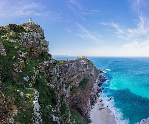
Looking from behind the old lighthouse (at top left) to the new lighthouse (a sunlit speck of white very near the point). The lighthouses are (700 m) apart, and the new lighthouse 162 metres lower in altitude so as to remain visible during low cloud.
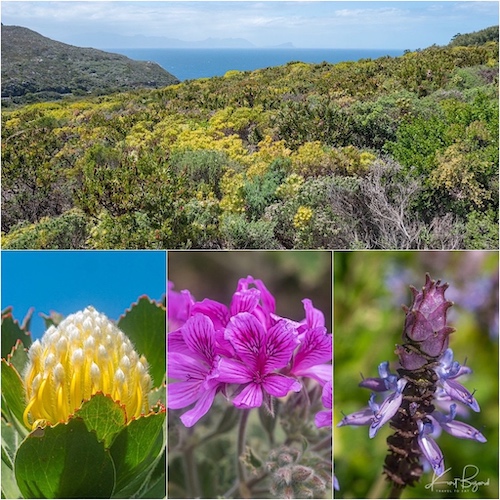
The Cape of Good Hope Nature Reserve (or Cape Point as it is colloquially called) is the crown jewel of the Table Mountain National Park. Cape Point falls within the southern section of Table Mountain National park. The natural vegetation of the area, the fynbos, comprises the smallest but richest of the world’s six floral kingdoms. This recognition by plant geographers of the Cape region of South Africa as a distinct major unit is because of its rich flora, which includes more than 1,500 genera, 30 percent of which are native nowhere else in the world. Almost any time of the year, one can find an exhilarating number of rare and beautiful flowers just by walking the fynbos.
I will end this introduction to the Cape Peninsula here, there will be more posts to come. With so much to do and such great natural beauty on display, a trip to the Cape of Good Hope should be a part of any visit to Capetown.
[mappress mapid=”252″]
References:
The Story of the Buffelsfontein Farm
Cape Town almost ran out of water. Here’s how it averted the crisis
What It’s Like To Live Through Cape Town’s Massive Water Crisis
Atlantic multi-decadal oscillation covaries with Agulhas leakage
Reconstruction of Ocean Current Behaviour around the Cape of Good Hope