
The lands now known as Rocky Mountain National Park have been home to humans for at least ten thousand years. Before the Europeans arrived, the area was known as the Kawuneeche Valley by the Ute Indians. The landscape reflects the culture of the people who have walked it, from Native Americans to the modern visitor. In the early 1900s, passion to conserve the area began to spread to Congress from chambers of commerce, conservationists, women’s clubs, Enos Mills, Colorado Mountain Club, and RB Marshall of the U.S. Geological Survey. Congress heard opposition from the Front Range Settlers League of Estes Park, ranchers, cattlemen, and even miners. This controversy finally resulted in the formation of the Rocky Mountain National Park in 1915. Highway 34, known as Trail Ridge Road through the park, runs from the town of Estes Park on the east to Grand Lake on the southwest. The road reaches an elevation of 12,183 feet (3,713 m), and is closed by snow in winter.


The Ute Tribe visited the west side of the park, particularly around Grand Lake as long as 6,000 years ago. The area of the park was Ute territory, used for camping and hunting, until the late 1700s. Then they were driven over the Continental Divide by the Arapaho, who came from the east, who continued to enjoy the area around Estes Park until colonists of European descent arrived. In 1859, while on a hunting expedition, Joel Estes and his son discovered the meadows that eventually became Estes Park. He moved his family there in 1860 and raised cattle. He stayed only until 1866, forced out by long, harsh winters. Enos Mills, then a 14-year-old boy, moved to Estes Park in 1884. He explored the mountains of the area and wrote many books and articles describing the region. He later supported the creation of Rocky Mountain National Park, and he split his time between the mountains he loved and the cities of the eastern United States, where he lobbied for the legislation to create the park. The legislation was drafted by James Grafton Rogers, a Denver lawyer and avid outdoorsman.


Rivers are part of the hydrological cycle. Water generally collects in a river from precipitation through a drainage basin from surface runoff and other sources such as groundwater recharge, springs, and the release of stored water in natural ice and snowpacks (e.g. from glaciers). With global warming, permanent glaciers are becoming a thing of the past, so different mechanisms need to come into play to provide a continuous flow of water. The Kawuneeche Valley is typical of the high mountain meadows that feed the regions streams and rivers. This valley however is special, a gigantic meadow with porous loamy soil that serves as the headwaters of the Colorado River, the most important river in the Southwest of the United States. The meadows act like a sponge, absorbing the runoff from the winter snow and gradually releasing it over the summer.


Aside from the hydrodynamics going on beneath the surface, the scenery on top is breathtaking. The beavers, moose, deer and other animals contribute to the scenery and the maintenance of the meadows.


The Colorado River goes around Grand Lake and it’s associated reservoirs on it’s downward trek toward the southwest. These two photographs show the Colorado River at the level of Grand Lake, at the site of my nieces wedding. You can clearly see the increase in volume in the flow of the river.


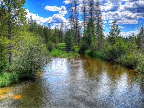
By the time the Colorado River reaches Granby, it has the recognizable form of a river, which grows with every passing mile.


By the time the Colorado River reaches Las Vegas, far from Colorado, it has become a formidable force of nature and the lifeline for such diverse communities as Las Vegas, Phoenix, the California Central Valley and Los Angeles. Known for its dramatic canyons and whitewater rapids, the Colorado is a vital source of water for agricultural and urban areas in the southwestern desert lands of North America. A river flowing in its channel is a source of energy which acts on the river channel to change its shape and form. In 1757, the German hydrologist Albert Brahms empirically observed that the submerged weight of objects that may be carried away by a river is proportional to the sixth power of the river flow speed. This formulation is also sometimes called Airy’s law. Thus, if the speed of flow is doubled, the flow would dislodge objects with 64 times as much submerged weight. This law accounts for the formation of the Grand Canyon. Since the mid-20th century, intensive water consumption has dried the lower 100 miles (160 km) of the river such that it no longer reaches the sea except in years of heavy runoff. If you visit Colorado, try to visit Rocky Mountain National Park, the headwaters of the mighty Colorado River.
[mappress mapid=”52″]
References:
Rocky Mountain National Park: http://www.nps.gov/romo/index.htm
Kawuneeche Valley: http://www.nps.gov/romo/kawuneeche_valley.htm
Hoover Dam: /hoover-dam-las-vegas-nevada/