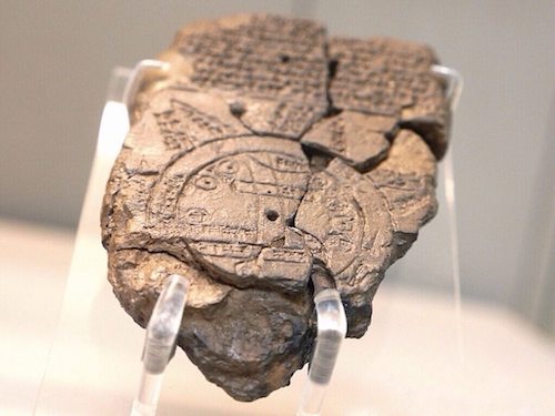

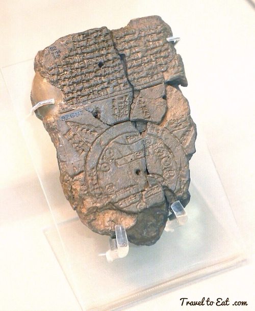
This cuneiform map of the Babylonian world is an archeological treasure on a par with the Rosetta Stone and the code of Hammurabi. The Babylonian World Map, also known as Imago Mundi is usually dated to the 6th century BCE and is the one of the oldest known world maps and certainly the most famous. We saw this when we were at the British Museum for the Olympics and I thought I would do some posts on famous ancient maps. An inscription on the Babylonian World Map indicates that it was a copy of a previous map and the locations featured on the map indicate that the original could not have been created earlier than the 9th century BCE. The back of the tablet is covered with cuneiform mainly describing Seven Islands or regions which are depicted in the form of equal triangles rising beyond the circle of the Earthly Ocean.

The Imago Mundi was discovered at Sippar, southern Iraq, 60 miles north of Babylon on the east bank of the Euphrates River, and published in 1899. Despite the fact that thousands of cuneiform tablets have been recovered at the site, and are still being studied at the British Museum, relatively little is known about the history of Sippar. A clay cone with cuneiform inscriptions, seen above, commemorating the construction of the walls of Sippar by Hammarabi (see my post) in the 18th century BCE was found there, indicating it was an very old city.

The tablet is oriented toward the northeast. It shows Babylon on the Euphrates, surrounded by a circular landmass with Assyria, Uratu (Armenia), Ocean and islands arranged around, forming a seven-pointed star. Interestingly enough, the map deliberately omits the powerful empires of Persia and Egypt which were well known at the time. Other important cities are placed on the map relative to their location from Babylon. The Euphrates begins in the mountains and ends in a marsh. Bit Yakinu refers to the “sea people's” of southern Sumeria. The map is often described as centered on Babylon when in fact the center is south of Babylon, probably in Nippur, considered a sacred city, important for the famous shrine of Enlil, the “Lord Wind,” ruler of the cosmos subject to only An. Traditionally, the king that controlled Nippur was considered king of Babylonia. The “spout” coming from the circular “Ocean” and ending in the Euphrates may represent the Persian Gulf, the cuneiform is damaged.
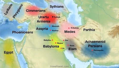
The map is sometimes taken as a serious example of ancient geography, but although the places are shown in their approximately correct positions, the real purpose of the map is to explain the Babylonian view of the mythological world. As you can see in the map I constructed above, the physical locations are indeed approximate. I think this may be intentional. While the large rectangle representing Babylon lies near the center, divided by the life giving Euphrates, Assyria, Armenia and other important cities are shown on the sidelines, as much smaller circles, metaphorically watching the show. As an aside, it was during this time period that the Armenians in Urartu and the Kurds in Media established their homelands although some scholars feel the Kurds descended from Parthia. Darius I in his famous trilingual Behistun Inscription (see my post on Hammarabi) calls the region Armina/Armenia in Old Persian and Urashtu/Urartu in Babylonian, clearly equating the two, suggesting that both are part of the same continuous entity.

The more literal interpretations feel there should be eight islands, to account for the four directions. The diagram above shows that this cannot be correct due to crowding of the triangles, especially island three. To me, this is additional confirmation the symbolic nature of the map. According to Babylonian ideas, the islands were said to lie between the Earthly and the Heavenly Oceans and connected the heavens and the earth. These islands form bridges to the Heavenly Ocean, where there are the various animal constellations, 18 of which are mentioned by name. This is a slightly different concept from that of the early Greeks, for whom the encircling ocean was outside of all known lands. These animal constellations are not the same as our zodiac but the concept is the same. The circular movements of the constellations are reminiscent of a river perhaps contributing to one translation of the Earthly Ocean as a “bitter river”. The cuneiform text describes these islands, and it seems that strange and mythical beasts as well as great heroes lived there, although the text is far from complete. The descriptions of the first and second islands are not preserved.
- the third island is where “the winged bird ends not his flight,” i.e., cannot reach.
- on the fourth island “the light is brighter than that of sunset or stars”: it lay in the northwest, and after sunset in summer was practically in semi-obscurity.
- The fifth island, due north, lay in complete darkness, a land “where one sees nothing,” and “the sun is not visible.”
- the sixth island, “where a horned bull dwells and attacks the newcomer”
- the seventh island lay in the east and is “where the morning dawns.”
The Sumerians and Babylonians probably had some knowledge, possibly acquired from other people, of the northern high latitudes and of the polar nights.

The Sumerians and Babylonians probably had some knowledge, possibly acquired from other people, of the northern high latitudes and of the polar nights. The 18 mythological animals allude to the Babylonian Epic of Creation where the mythological animals were expelled to the “Heavenly Ocean” to make way for the creation of a new world. It has been debated as to whether the seven islands represent actual geographical locations. More importantly for the Babylonians, however, the islands symbolically connect them, simultaneously, with their past and the spiritual realm. This bird’s eye view of the world puts man at the center of the spiritual universe. Although the significance of the star-like map is unclear, this final form indicates the maps symbolic rather than literal orientation.

In short, the “Babylonian world map” can better be understood as the map of the cosmos symbolically featuring Babylon as the center of the universe and intentionally connecting them to a higher realm from which they drew meaning for their existence. This map, like many maps, told what was most important to its particular culture. Future maps would draw from this kind of stylization including the classical tripartite maps that divided the world between Asia, Europe, and Africa. As a legacy of these Babylonian concepts, theology still strives to unite heaven and earth.

The backdrop of time between the 10th and 6th century BCE was tumultuous for the region. Between 1206 and 1150 BCE, the bronze age cultural collapse of the Mycenaean kingdoms, the Hittite Empire in Anatolia and Syria, and the New Kingdom of Egypt in Syria and Canaan interrupted trade routes and severely reduced literacy. The gradual end of the Dark Age that followed saw the eventual rise of the Lydian and Phrygian states in Anatolia (modern day Turkey), Aramaean kingdoms in modern day Syria, and the eventual rise of the Neo-Assyrian Empire. Interestingly, even though the Arameans were absorbed into the Neo-Assyrian empire, their language become the standard for the region. The coastal kingdoms along the Mediterranean in the Levant became a common target as a possible entry points into Egypt and for trade.


Of particular note is the famous Sargon II, under his rule the Assyrians completed the defeat of the Kingdom of Israel, capturing the capital Samaria after a siege of three years and exiling the inhabitants. This became the basis of the legends of the Lost Ten Tribes of Israel in 720 BCE. “As for Hezekiah the Judean… I locked him up within Jerusalem, his royal city, like a bird in a cage.” Sargon scarcely stopped fighting throughout his reign. A campaign in 714 BC weakened the powerful northern state of Urartu and in 710 BC he retook Babylonia, defeating Marduk-apla-iddina and Elam, thus becoming the king of both Babylon and Assyria. In 1847 archeologists discovered the prism shown to the right dated from the early 8th century which has a royal inscription describing his conquests. It mentions Bit-Haban, one of the places on the Babylonian World map. This is the only reference I could find concerning this place name although it does not say where it is. These cylinders were written in Nimrud, Assyria, before being sent to Babylonian cities to be deposited in the foundations of in buildings in Babylonia, a common practice for kings of Babylon.

In 609 the Neo-Assyrian empire collapsed and was replaced by the Median and the Neo-Babylonian empires for about 50 years, to be replaced in turn by the Archaemenid Persians under Cyrus the Great. He respected the customs and religions of the lands he conquered, being well recognized for his achievements in human rights, politics, and military strategy, as well as his influence on both Eastern and Western civilizations. The famous Cyrus Cylinder, seen above, is a declaration in Akkadian cuneiform script (Cyrus was Persian) in the name of the Cyrus the Great, of his conquest of Babylon in 539 BC and capture of Nabonidus, the last Babylonian king. It was created and used as a foundation deposit following the Babylonian tradition. He claims to have achieved this with the aid of Marduk, the god of Babylon. He then describes measures of relief he brought to the inhabitants of the city, and tells how he returned a number of images of gods, which Nabonidus had collected in Babylon, to their proper temples throughout Mesopotamia, the Levant and western Iran. At the same time he arranged for the restoration of these temples, including the temple in Jerusalem, and organized the return to their homelands of a number of people who had been held in Babylonia by the Babylonian kings. Although the Jews are not mentioned in this document, their return to Palestine following their deportation by Nebuchadnezzar II, was part of this policy. Construction of the Second Temple in Jerusalem began in 538 BCE, to be completed 23 years later, during the reign of Darius the Great. This cylinder has sometimes been described as the “first charter of human rights”.

Anaximander who died 546 BCE is credited with a map of the world seen to the right, which was circular in form and showed the known lands of the world grouped around the Aegean Sea at the center. This was all surrounded by the ocean as in the Imago Mundi but without “Islands”. Note the three part division into Europe, Africa and Asia which would be repeated on future maps. Also there is no depiction of the Red Sea or the Persian gulf, despite the well established trade between Greece, Egypt and Babylon.

Hecataeus of Miletus who died in 476 BCE, is credited with a work entitled Ges Periodos (World Survey), in two books each organized in the manner of a periplus, a point-to-point coastal survey. Hecataeus described the countries and inhabitants of the known world, the account of Egypt being particularly comprehensive; the descriptive matter was accompanied by a map, based upon Anaximander’s map of the earth, which he corrected and enlarged. This map does show the Red Sea but no Persian gulf. Note that he shows the people inhabiting these lands with pretty good accuracy and shows India, a trading partner with Greece by this time. The work only survives in some 374 fragments.
In conclusion, the Babylonian World Map represents a remarkable view on theology and geography within a backdrop of war and political turmoil. Taken in context with other documents of this time period, it promotes concepts that impacted Greece and the subsequent development of religion and geography in the west. The Imago Mundi embodies the aspirations, theology and world view of Babylonia in a very unique way. What a fascinating bit of clay!
Even for me this is a long post but I hope the subject matter and pictures were worth the reading.

References:
Schoyen Collection: http://www.schoyencollection.com/index.html
Henry Davis: http://www.henry-davis.com/MAPS/AncientWebPages/103Amono.html
Digital History: http://teachingdigitalhistory.ning.com/forum/topics/narrative-map-histories
The Fourth Part of the World (2009) by Tony Lester: http://www.amazon.com/The-Fourth-Part-World-America/dp/1416535314