
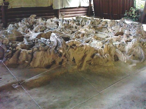
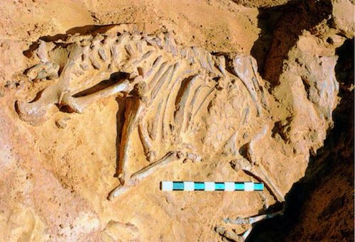
Dolní Věstonice is an open-air site located along a stream, in the south Czech Republic on the northern slopes of the Pavlovske Hills, close to the village of Pavlov. Its people hunted mammoths and other herd animals, saving mammoth and other bones that could be used to construct a fence-like boundary, separating the living space into a distinct inside and outside. In this way, the perimeter of the site would be easily distinguishable. At the center of the enclosure was a large bonfire and huts were grouped together within the barrier of the of the mammoth bones. The radiocarbon dates for the occupations at DVII are 27,070-25,570 years uncal BP, which calibrates to 31,500 years ago according to the INTCAL calibration curve (Reimer et al. 2009). The mammoth deposit (202 bones) is generally thought to be contemporary with one or more of these occupations and has been dated to 26100 uncal BP (Svoboda, 1991).
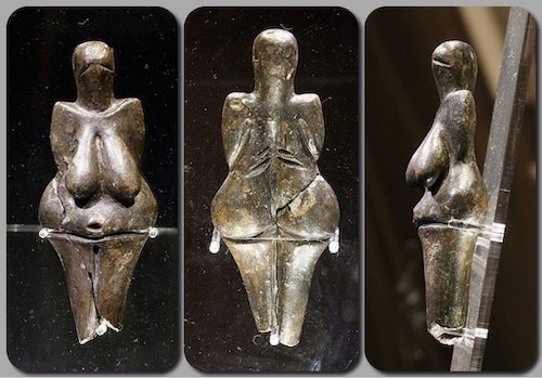
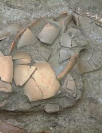
Dolní Věstonice is the location in which the famous Venus of Dolní Věstonice was found in a kiln near the settlement. It has a height of 111 millimetres (4.4 in), and a width of 43 millimetres (1.7 in) at its widest point and is made of a clay body fired at a relatively low temperature. This figurine, together with a few others from nearby locations, is the oldest known ceramic article in the world. In addition to the Venus figurine, figures of animals – bear, lion, mammoth, horse, fox, rhino and owl – and more than 2,000 balls of burnt clay have been found at Dolní Věstonice.
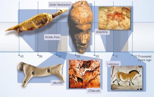
Shown above is a timeline of ice age art, illustrating sites that may be familiar to you along with their relative ages. By the way, the British Museum currently has an exhibition of Ice Age Art which I am planning to see and you may be interested as well.
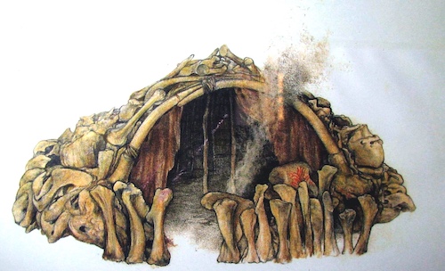
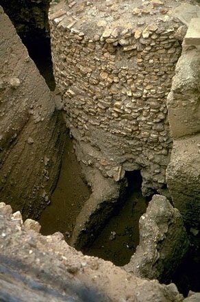
At Mezhirich in 1965, a farmer dug up the lower jawbone of a mammoth while in the process of expanding his cellar. Further excavations revealed the presence of four huts, made up of a total of 149 mammoth bones. These dwellings, dating back some 15,000 years, were determined to have been some of the oldest shelters known to have been constructed by pre-historic man. Mezhirich or Mezhyrich or Межиріч, is a village in central Ukraine.
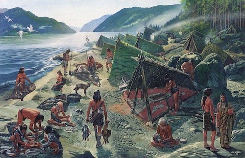
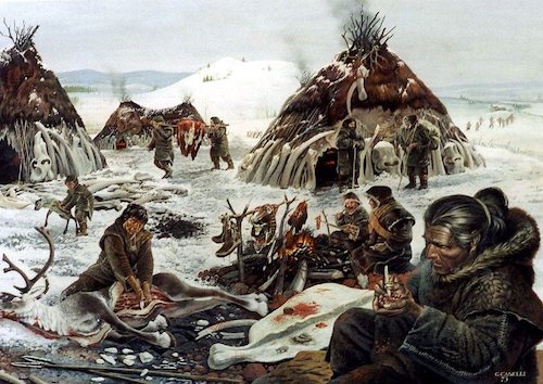
Lepenski Vir as it was 8 000 years ago, when it was a thriving community on a restricted area on the right bank of the Danube River, in the middle of the Djerdap, the Iron Gates Gorge. This superb image is displayed here by kind permission of the artist Giovanni Caselli, a master craftsman and artist with a very broad knowledge of archaeology. Note the fish trap, baskets of fish, the trapezoidal house under construction, the stone hearth, the aurochs and deer, the water birds which have been caught, the spears and bow and arrow, the dog/wolf, the making of a sculpture, and the clothes.

When our ancient ancestors decided to settle down, instead of hunting and gathering, they needed homes to shut out the cold and rain. The earliest homes were built from mud brick or timber and most traces of them have disappeared. What has remained are shards of pottery, stone tools and fire hearths. The earliest hearths are at least 790,000 years old, and some researchers think cooking may reach back more than 1.5 million years. Control of fire provided a new tool with several uses; including cooking, which led to a fundamental change in the early human diet. Cooking released nutrients in foods and made them easier to digest. It also rid some plants of poisons.
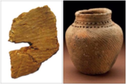
It used to be thought that the beginning of pottery was associated with agriculture and sedentary lifestyle. But in the past 10 years, researchers have found instances of pottery pre-dating agriculture. The earliest farming societies in the Near East did not use pottery. Early Japanese societies used pottery before developing agriculture. At Lake Anenuma in Honshu, Japan 12,000 year old pottery has been found. Archaeologists have determined that fragments from a large bowl found in Xianrendong Cave, Jiangxi Province, are 20,000 years old, about 8,000 years older than the oldest Japanese pottery.
Nabta Playa was once a large basin of water in the Nubian Desert, located approximately 800 kilometers south of modern day Cairo or about 100 kilometers west of Abu Simbel in southern Egypt. Archaeological findings indicate human occupation in the region dating to at least somewhere around the 10th and 8th millennia BC. Fred Wendorf and Christopher Ehret have suggested that the people who occupied this region at that time were early cattle pastoralists.
The people of that time consumed and stored wild sorghum, and used ceramics adorned by complicated painted patterns created perhaps by using combs made from fish bone and which belong to a general pottery tradition strongly associated with the southern parts of the sahara. The earliest pottery at Nabta Playa dates between 9,800 and 8,000 bp, at least 1500 years before the appearance of plant domestication or sedentism. By the 7th millennium BC, exceedingly large and organized settlements were found in the region, relying on deep wells for sources of water. Huts were constructed in straight rows. Sustenance included fruit, legumes, millets, sorghum and tubers. Also in the late 7th millennium BC, but a little later than the time referred to above, imported goats and sheep, apparently from Southwest Asia, appear. Many large hearths also appear. The local emphasis on cattle may have a connection to pre-dynastic Egypt.
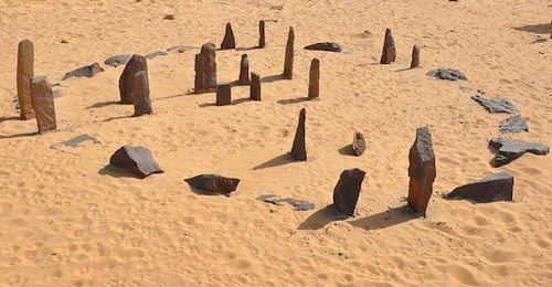
By the 5th millennium BC these peoples had fashioned one of the world's earliest known astronomical device (roughly contemporary to the Goseck circle in Germany), about 1000 years older than but comparable to Stonehenge. Research suggests that it may have been a prehistoric calendar which accurately marks the summer solstice. Findings also indicate that the region was occupied only seasonally, most likely only in the summer period, when the local lake filled with water for grazing cattle.
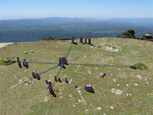
By far the oldest stone circle has been “suggested” in Mpumalanga, South Africa to be 750 thousand years old, the Adam's Calendar. Many ancient stone ruins have also been found in the vicinity. I don't want to be cynical but this has been the subject of a rather sensationalist book.
The beginning of the Neolithic culture is considered to be in the Levant (Jericho, modern-day West Bank) about 10,200–8,800 BC. It developed directly from the Epipaleolithic Natufian culture in the region, whose people pioneered the use of wild cereals, which then evolved into true farming. The Natufian period was between 12,000 and 10,200 BC, and the so-called “proto-neolithic” is now included in the PPNA (Pre-Pottery Neolithic A) between 10,200 and 8,800 BC. As the Natufians had become dependent on wild cereals in their diet, and a sedentary way of life had begun among them, the climatic changes associated with the Younger Dryas are thought to have forced people to develop farming. By 10,200–8,800 BC, farming communities arose in the Levant and spread to Asia Minor, North Africa and North Mesopotamia. Early Neolithic farming was limited to a narrow range of plants, both wild and domesticated, which included einkorn wheat, millet and spelt, and the keeping of dogs, sheep and goats. By about 6,900–6,400 BC, it included domesticated cattle and pigs, the establishment of permanently or seasonally inhabited settlements, and the use of pottery. Several Levantine cities (Jericho, Byblos, Damascus, Sidon and Beirut) seem to hold the record for the first cities.
The most striking aspect of the early Jericho was a massive stone wall over 3.6 meters high, and 1.8 meters wide at the base, making this the first walled town in history. Inside this wall was a tower over 3.6 meters high which contained an internal staircase with 22 stone steps. The wall and tower were unprecedented in human history, and would have taken a hundred men more than a hundred days to construct it.
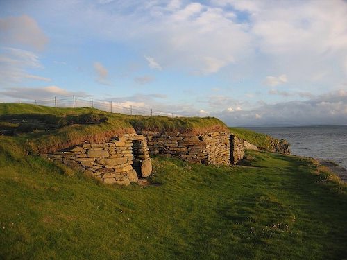
The oldest Neolithic house in Northern Europe is at Knap of Howar on the island of Papa Westray in Orkney, Scotland. Radiocarbon dating shows that this farmstead was occupied from 3700 BC to 2800 BC, earlier than the similar houses in the settlement at Skara Brae on the Orkney Mainland.

Stonehenge represents just one of a worldwide phenomena of stone circles and megaliths. Archaeologists believe it was built anywhere from 3000 BC to 2000 BC. Radiocarbon dating in 2008 suggested that the first stones were raised between 2400 and 2200 BC, while another theory suggests that bluestones may have been raised at the site as early as 3000 BC. Archaeologists have found four, or possibly five, large Mesolithic postholes (one may have been a natural tree throw), which date to around 8000 BC, beneath the nearby modern tourist car-park. These held pine posts around 0.75 metres (2 ft 6 in) in diameter which were erected and eventually rotted in situ. Stonehenge appears to have been both a cemetery and a celestial observation project.
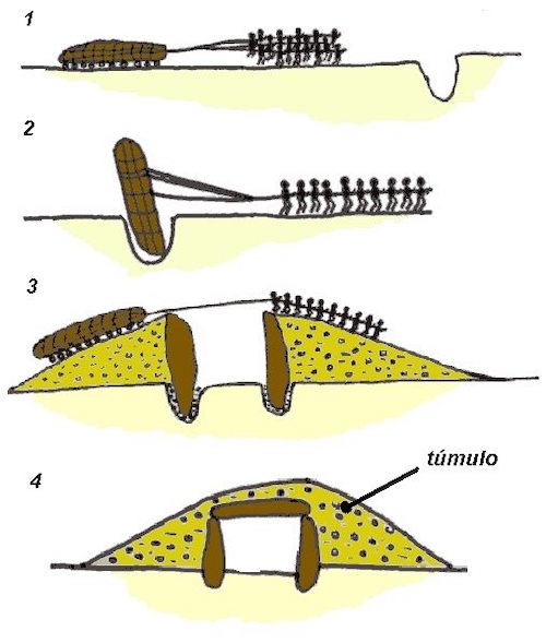
People almost always want to know how the builders created these massive monuments. Current thinking is described in the figure above, the vertical stones are placed first, after which a hill of earth us created to lay the capstone. The earth can then be removed or added to, to create a tumulus or hill.
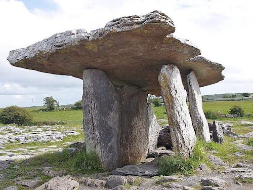
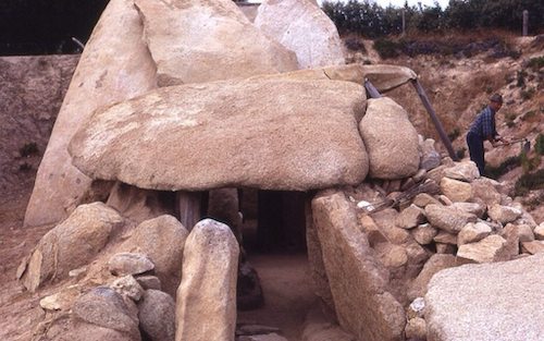
A dolmen, also known as a portal tomb, portal grave, or quoit, is a type of single-chamber megalithic tomb, usually consisting of three or more upright stones supporting a large flat horizontal capstone (table), although there are also more complex variants. Most date from the early Neolithic period (4000 to 3000 BC). Dolmens were usually covered with earth or smaller stones to form a barrow, though in many cases that covering has weathered away, leaving only the stone “skeleton” of the burial mound intact. The Anta Grande do Zambujeiro (Great Dolmen of Zambujeiro) dates from 4000-3500 BC. It is one of the largest dolmen in Europe. Dolmen can be found all over the world, surprisingly Korea has more dolmens than anywhere else.
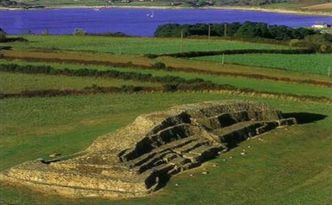
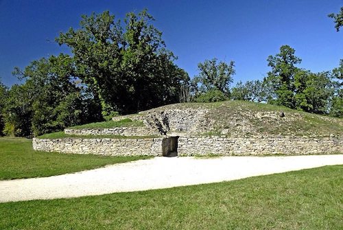
Barnenez Tumulus, is a Neolithic monument located near Plouezoc'h, on the Kernéléhen peninsula in northern Finistère, Brittany (France). It dates to the early Neolithic, about 4500 BC; it is considered one of the earliest and largest megalithic monuments in Europe. It is also remarkable for the presence of megalithic art. The cairn was first mapped in 1807, in the context of the Napoleonic cadaster. Its first scientific recognition took place in the context of an academic congress in Morlaix in 1850, when it was classified as a tumulus. Privately owned until the 1950s, the cairn was used as a quarry for paving stones. This activity, which threatened to destroy the monument, was only halted after the discovery of several of its chambers in the 1950s. The local community then took control of the site. Similar, possibly contemporary, monuments are known at 22 other locations in France and on Jersey. Breton examples are Larcuste-Colpo, Le Bono, Petit Mont, Ty-Floc´h, Gavrinis, Île Carn, Ploudalmézeau and Guennoc (I´ile Gaignoc – sometimes spelt Guénioc) off the shore at Landéda.
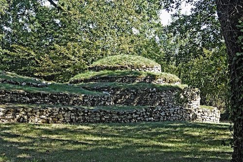
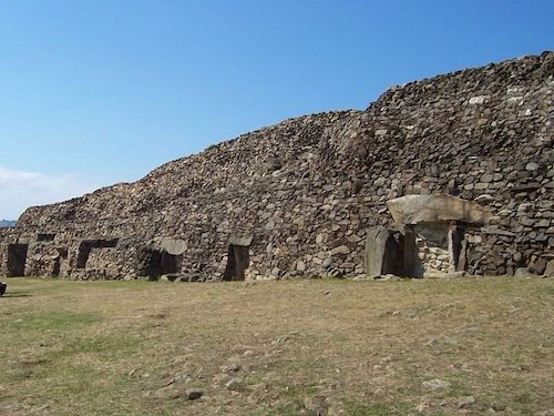
The Tumulus of Bougon or Necropolis of Bougon is a group of five Neolithic barrows located in Bougon near La-Mothe-Saint-Héray, between Exoudon and Pamproux in Poitou-Charentes, France. Their discovery in 1840 raised great scientific interest. To protect the monuments, the site was acquired by the department of Deux-Sèvres in 1873. Excavations resumed in the late 1960s. The oldest structures of this prehistoric monument date to 4800 BC. The F tumulus was built in the first half of the 5th millennium BC and reused in the 3rd millennium BC. It is one of the oldest examples of monumental architecture in Atlantic France. Excavation in 1977 revealed a steep hemispherical mound containing a circular structure of 2.5 m in diameter. It lies within a triple concentric drystone facade and is covered with a corbelled vault. The architecture is similar to the complex of Er-Mané near Carnac, Brittany. The tomb, which dates from about 4700 BC, contained the unarticulated remains of about ten individuals, half of them children. A layer of red clay had been placed atop the natural floor level. There were few artifacts, mainly two pots, six bone chisels and some flint tools.
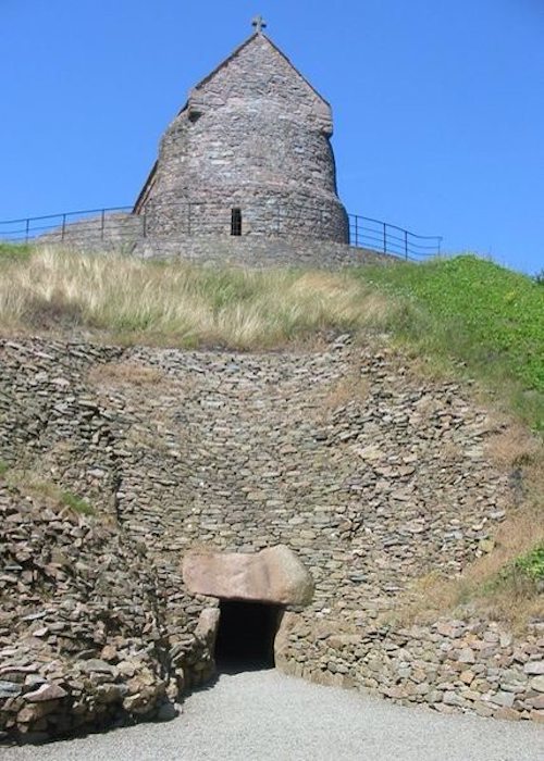
La Hougue Bie is a Neolithic ritual site which was in use around 3500 BC. In Western Europe, it is one of the largest and best preserved passage graves and the most impressive and best preserved monument of Armorican Passage Grave group. Although they are termed “passage graves”, they were ceremonial sites, whose function was more similar to churches or cathedrals, where burials were incidental. Since the excavations and restoration of the original entrance of the passage observations from inside the tomb at sunrise on the spring and autumn equinox have revealed that the orientation of the passage allows the sun's rays to shine through to the chamber entering the back recess of the terminal cell. The site consists of 18.6 meter long passage chamber covered by a 12.2 meter high earth mound. The site was first excavated in 1925 by the Société Jersiaise. Fragments of twenty vase supports were found along with the scattered remains of at least eight individuals. The Channel Islands (in contrast with mainland Brittany, where they are rare), have five passage graves with side chambers (La Hougue Bie, Faldouet and Grantez in Jersey, La Varde and Le Déhus in Guernsey).
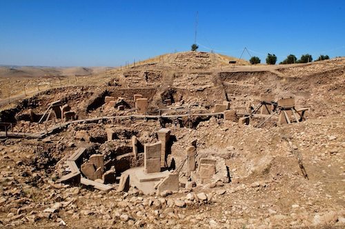
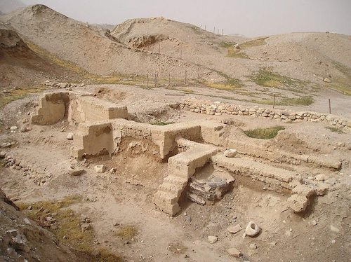
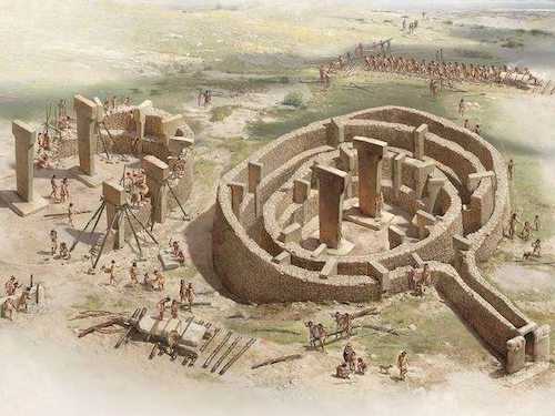
Göbekli Tepe (Turkish for “Hill with a potbelly”) is a hilltop sanctuary erected on the highest point of an elongated mountain ridge some 15 km northeast of the town of Sanliurfa (formerly Urfa / Edessa) in southeastern Turkey. The site was erected by hunter-gatherers in the 11th millennium BC before the advent of the Neolithic package of farming and tending domesticated animals. Mysteriously, the entire complex of stones, pillars and carvings was then deliberately buried in 8200 BC. Together with Nevalõ Cori, it has revolutionized understanding of the Eurasian Neolithic age, or at the very least it has posed a lot of unanswered questions.
Not only its large dimensions, but the side-by-side existence of multiple pillar shrines makes the location unique. There are no comparable monumental complexes from its time. Nevalı Çori, a well-known Neolithic settlement also excavated by the German Archaeological Institute and submerged by the Atatürk Dam since 1992, is 500 years later, its T-shaped pillars are considerably smaller, and its shrine was located inside a village; the roughly contemporary architecture at Jericho is devoid of artistic merit or large-scale sculpture; and Çatalhöyük, perhaps the most famous of all Anatolian Neolithic villages, is 2,000 years younger.
Göbekli Tepe was first examined—and dismissed—by University of Chicago and Istanbul University anthropologists in the 1960s. As part of a sweeping survey of the region, they visited the hill, saw some broken slabs of limestone and assumed the mound was nothing more than an abandoned medieval cemetery. In 1994, Klaus Schmidt was working on his own survey of prehistoric sites in the region. After reading a brief mention of the stone-littered hilltop in the University of Chicago researchers' report, he decided to go there himself. From the moment he first saw it, he knew the place was extraordinary.
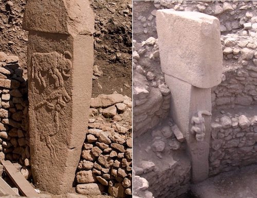
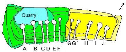
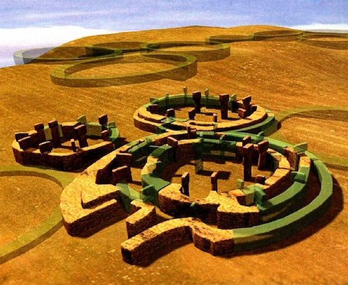
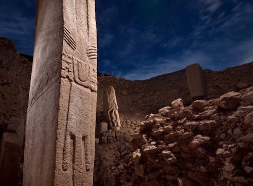
Göbekli Tepe is the world's oldest known religious structure. The site contains 20 round structures which had been buried, four of which have been excavated. Each round structure has a diameter of between 10 and 30 meters (30 and 100 ft) and all are decorated with massive, mostly T-shaped, limestone pillars that are the most striking feature of the site. The pillars are big, the tallest are 18 feet in height and weigh 16 tons. Swarming over their surfaces was a menagerie of animal bas-reliefs, each in a different style, some roughly rendered, a few as refined and symbolic as Byzantine art. Two pillars are at the centre of each circle, possibly intended to help support a roof, and up to eight pillars are evenly positioned around the walls of the room. The spaces between the pillars are lined with unworked stone and there are stone benches between each set of pillars around the edges of the wall.
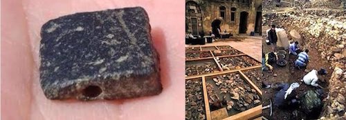
Other parts of the hill were littered with the greatest store of ancient flint tools Schmidt had ever seen, a Neolithic warehouse of knives, choppers, and projectile points. Even though the stone had to be lugged from neighboring valleys, Schmidt says, “there were more flints in one little area here, a square meter or two, than many archaeologists find in entire sites.” There were also thousands of slaughtered animals, many of the ones depicted on the pillars. Puzzle piled upon puzzle as the excavation continued. For reasons yet unknown, the rings at Göbekli Tepe seem to have regularly lost their power, or at least their charm. Every few decades people buried the pillars and put up new stones, a second, smaller ring, inside the first. Sometimes, later, they installed a third. Then the whole assemblage would be filled in with debris, and an entirely new circle created nearby. The site may have been built, filled in, and built again for centuries.
Bewilderingly, the people at Göbekli Tepe got steadily worse at temple building. The earliest rings are the biggest and most sophisticated, technically and artistically. As time went by, the pillars became smaller, simpler, and were mounted with less and less care. Finally the effort seems to have petered out altogether by 8200 B.C. Before they left for good, the builders covered the entire complex in dirt.
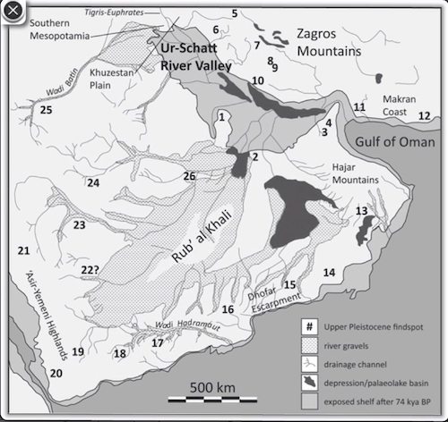
I am going to stop here but I would like to make a final point. Veiled beneath the Persian Gulf, a once-fertile landmass may have supported some of the earliest humans outside Africa some 75,000 to 100,000 years ago, a new review of research suggests. This map reveals the Persian Gulf with regions that were exposed as sea levels fell. At its peak, the floodplain now below the Gulf would have been about the size of Great Britain, and then shrank as water began to flood the area. Then, about 8,000 years ago, the land would have been swallowed up by the Indian Ocean, according to study researcher Jeffrey Rose, an archaeologist at the University of Birmingham in the U.K. “Perhaps it is no coincidence that the founding of such remarkably well developed communities along the shoreline corresponds with the flooding of the Persian Gulf basin around 8,000 years ago,” Rose said. “These new colonists may have come from the heart of the Gulf, displaced by rising water levels that plunged the once fertile landscape beneath the waters of the Indian Ocean.”
References:
Giovanni Caselli: http://www.giovannicaselli.com/IT/ESSAYS%20PAGE.htm
Earliest pottery: http://www.bbc.co.uk/news/science-environment-18602281
Jericho Wall: http://www.bible-architecture.info/Jericho.htm
Adam's Calendar: http://www.mpumalanga.com/index.php?att_view+6801
Adam's Calendar: http://www.flickeringtorches.com/2009/12/04/exposing-the-lost-city-of-enki.html
Megaliths: http://www.megalithic.co.uk/topics.php?countries=1
Dolmen: http://en.wikipedia.org/wiki/Dolmen
Dolmen: http://www.ancient-wisdom.co.uk/dolmen.htm#dolmen%20gallery
Tall el-Hammam Dolmen: http://www.tallelhammam.com/uploads/TeHEP_Discovery_2.pdf
Göbekli Tepe: http://archive.archaeology.org/0811/abstracts/turkey.html
From Cave Paintings to the Internet: http://www.historyofinformation.com/expanded.php?category=Architecture+%2F+Design
Mezhirich / Mezhyrich / Межиріч – Mammoth Camp: http://donsmaps.com/mammothcamp.html
Cradles of Civilization: http://www.ancientsuns.com/ancient-earth.php
Göbekli Tepe National Geographic: http://ngm.nationalgeographic.com/2011/06/gobekli-tepe/mann-text
Göbekli Tepe Klaus Schmidt: http://arheologija.ff.uni-lj.si/documenta/authors37/37_21.pdf
Live Science: http://www.livescience.com/10340-lost-civilization-existed-beneath-persian-gulf.html